Two-wheelin' on a legendary Cascades trail
Mark Morical | Hagadone News Network | UPDATED 12 years, 3 months AGO


MCKENZIE BRIDGE, Ore. (AP) - It might be the most thrilling, most scenic trail in Oregon - perhaps even in the entire Northwest.
But the 26 1/2-mile long McKenzie River National Recreation Trail, even with 1,600 feet of descent, is a grind of a ride.
The upper half is especially so because of all the lava rock mountain bikers must negotiate. In some spots, hikers are faster than riders.
Knowing this, I set out recently to ride the smoother, tamer lower 15 miles of the renowned trail. The last time I rode the entire McKenzie River Trail, it took me six hours. This time around, a three-hour ride sounded much more inviting.
The trail is located pretty much halfway between Bend and Eugene along state Highway 126. I had worked in Eugene the previous day, so I drove from there to meet up with some friends coming from Bend, Dustin Gouker and Jesse Cooke, at the McKenzie Bridge Ranger Station.
The plan was to do a shuttled ride from Trail Bridge Reservoir, the midpoint of the trail, down to the ranger station. That way, we could get the flavor of the trail without all that pesky lava rock.
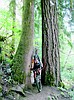
The McKenzie River Trail is known for the clear, rushing water of the river, spectacular waterfalls and towering old-growth Douglas fir trees. But another reason mountain bikers drool over the trail is simply the nature of the path itself.
It starts out easy around the west side of Clear Lake and becomes extremely technical over the rugged lava rock near Sahalie and Koosah falls all the way to Trail Bridge Reservoir.
Then, just when you're totally cooked and can't go on, the trail turns into a smooth, easy ride along flowing singletrack all the way down to the ranger station. That section of trail was what we were seeking.
We hooked the bikes onto the rack on Dustin's car and drove up the highway from the ranger station to Trail Bridge Reservoir, where a father and son were crossing the highway with a stringer of trout.
Dustin parked on a gravel road near the reservoir, where we could access the trail.
The ride started with a challenging climb along some technical rock sections high above the water. We then surged down a fast descent, after which the trail took us hundreds of feet above the river again, past several cliffside corners where we had to ride slowly and with extra caution.
Most of the trail stays alongside the river, but some portions took us away from the water. One constant along the trail - and what makes it so different from any trail in Central Oregon - is the lush greenery of the Willamette National Forest. Bright green ferns, moss-covered Douglas firs and endless deciduous trees line the trail and provide a nearly constant canopy. On the day we rode, temperatures reached the 90s in Bend and Eugene, but it never felt warmer than 70 to me during the entire ride.
The mostly dust-free trail includes a few switchbacks, and on one of them Dustin took the turn a bit too fast and launched off the trail, down into a mess of green bushes on a steep hillside. I jumped off my bike and ran to help him, but the bushes were already keeping him from falling farther down toward the river.
His leg was stuck in his bike frame, and I lifted his bike as he worked to free himself. I got his bike up the slope and he made his way back up, injury-free except for a nasty scratch on his right leg ... and perhaps a bruised ego.
Crisis averted, we got back to the ride. The river provided cool air as we continued along the trail, which cuts through the Belknap Springs and Paradise campgrounds. At Paradise, we rode out to the highway and back down to the ranger station, where we had left my car.
We took several breaks along the way for food, water and photos, and we finished the 15 miles in about 2 1/2 hours. (Bikers should be sure to take along extra food and water and a bicycle repair kit.)
Because we skipped the upper portion of the trail, which includes the waterfalls, we stopped on the drive back home to Bend to hike along the trail and check out Sahalie and Koosah falls, which were surging with bright whitewater in the middle of the green forest.
We were not entirely exhausted by the end of the ride and the short hike, and we probably could have ridden a few more miles.
But I don't mind waiting for a return trip until fall, when the autumn colors will give the McKenzie River Trail even more stunning scenery.
ARTICLES BY MARK MORICAL
Two-wheelin' on a legendary Cascades trail
MCKENZIE BRIDGE, Ore. (AP) - It might be the most thrilling, most scenic trail in Oregon - perhaps even in the entire Northwest.

Mount Defiance an endurance challenge
HOOD RIVER, Ore. - The Mount Defiance Trail offers a steep, challenging ascent over loose shale to the highest point in the Columbia River Gorge.