Beauty on the border
David Cole | Hagadone News Network | UPDATED 12 years, 6 months AGO
High up on the Bitterroot Range on the Idaho-Montana border and north of Interstate 90 sit the two Blossom Lakes waiting to be discovered each summer.
On a sunny July 14, as part of a small group that included Coeur d'Alene Press photographer Shawn Gust, I hiked the trail leading to the larger Blossom Lake and its neighbor Upper Blossom Lake. The two are just barely on the Montana side of the border.
As an inexperienced hiker, I had to work for it in the heat, but a swim in the chilly waters of Upper Blossom Lake provided the perfect reward and left me wanting to return with friends again but to also do some camping and make a deeper push into the forest to the more remote Pear Lake.
Judy Reese, a forest geologist for the Lolo National Forest, said it appears the lakes are "tarns," which are small lakes formed in ice-gouged depressions within glaciated mountains.
As a disclaimer, she said, "The geologic environment of the area is very complex."
The lakes' popular neighbor, Revett Lake, another high-elevation body, is in Idaho and is much easier to access.
"I'm sure the Indians did use the area," said Milo McLeod, who spent 34 years as the Forest Service's archaeologist for the Lolo National Forest.
To date, though, archaeological evidence hasn't been found supporting their use, he said.
A diversion ditch was dug in the late 1800s to feed water from Blossom Lake to the town of Murray, in Idaho, for mining operations during a gold rush.
"Supposedly it was built by Chinese laborers," McLeod said. Many of those laborers toiled up on Prospect Creek, which streams out of Blossom Lake and supports cutthroat and bull trout.
That diversion ditch was never used, though, because a competitor of the mining operation destroyed the outlet damn with an explosion. On the hike we saw very little evidence of the ditch's former existence. The place appears wild and untouched.
•••
For our hike we parked at Thompson Pass. The skill-level rating is "easy" for the 6-mile-round-trip trek to the closer of the two, Blossom Lake, with a peak elevation of about 5,800 feet. The trailhead elevation is around 4,800 feet.
"I found the hike to be a challenge, but not too difficult for a fun day trip," said Erica Sponsler, a friend from Fargo, N.D., who squeezed the hike in during a short visit to Spokane for a funeral.
My group lost about 45 minutes at the outset after we started on the wrong trail from the parking lot. Only Gust had visited the lakes before.
"It had been quite a few years since hiking the area and the trails," Gust said. "After about 20 minutes or so in the wrong direction, the trail wasn't looking familiar."
Fortunately, the wrong trail led us into some exotic Canada lynx territory with patches of huckleberries that weren't quite ripe, but a small handful had a pleasant tartness.
We returned to the Thompson Pass parking lot and found a cyclist who knew the area and was able to point us to the correct trailhead.
She recommended we bring our bear spray, which none of us had. As we started along the trail we exchanged stories about past bear encounters, and agreed on a response if we happened upon one. We ended up spending more than six hours, with lots of stops, hiking to and from the lakes without seeing a bear or any wildlife at all.
"What I enjoyed the most was the quietness of the forest," said Sponsler, 24.
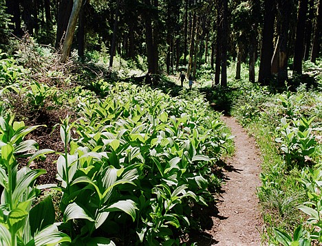
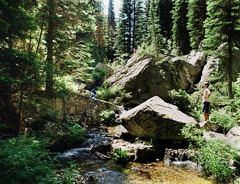
The sun filtered through the canopy cover high above us and rays came down and spotlighted the bright green undergrowth. The trees were covered in long beards of moss.
The hike in is mostly uphill, but the shade on the trail kept most of the day's sun off our backs and heads.
There were some big flies and plenty of mosquitoes along the way, but heavy bug repellent seemed to hold them off.
As point man on the trail I was surprised a couple times when mobs of flies would suddenly burst from a thick bunch of grass with an eruption of buzzing.
•••
Before we reached the first lake we came upon some clearings that provided expansive views of the forest. Shortly before we reached Blossom Lake we followed Prospect Creek, which stepped its way east and down the mountain, pooling here and there, allowing hikers to rinse their face or dip a hat in the cold water.
We stopped for a quiet and undisturbed lunch along the shoreline of Blossom Lake. We saw no more than 20 people the entire day.
As we headed for Upper Blossom Lake we started along the southeast shoreline on what appeared to be a rough, overgrown fishermen's trail.
Unable to continue busting through the brush, we backtracked and re-joined the main trail and made it to Upper Blossom Lake with ease. We enjoyed total seclusion while we were there.
Fields of snow were visible on the ridge above us to the southwest, signaling how cold the water would be. Small trout could easily be seen in the crystal clear water, occasionally dimpling the surface.
Every once in a while a strong breeze came down from the ridge, rustling the trees. It gave me a sense for how quickly the weather could change in this environment, and how winter is always close to tightening its grip.
A longtime friend, Aaron Swinkels, also of Fargo, was the first to go in the lake.
"The best way to enter the water at Upper Blossom Lake is with a three-ton plunge, as it is cold enough, even in July, to change your voice a few octaves," said Swinkels, 36.
I initially searched for a gentle slope to ease in, but the ground under the water is soft with some hidden tree trunks and limbs. I gave up and lunged forward, starting into an easy dog paddle. I knew it would be cold, and it was, to my taste, frigid.
After swimming for a while I got out and warmed in the sun. The second time in was much easier. I made a fast swim out to a bolder some ways off shore and stood on it, taking in the view and absorbing the moment.
I swam back to shore and quickly changed into dry clothes, feeling completely revitalized for the return trip.
After checking out the primitive but thoughtfully arranged campsite on the side of the lake, we all agreed we would return, stay for a night or two, and climb to Pear Lake.
We headed back to Blossom Lake, making it back down with little effort.
•••
We left it and headed about 100 yards down along Prospect Creek, where Swinkels used his water filter to fill our bottles.
The hike out was mostly downhill and seemed to take half the time. To me it felt like one group of leg muscles did all the work going up, and another carried the load coming down.
The day's hike gave Gust the chance to leave his digital camera gear, which he uses for The Press, at home. To document our trek he instead used his lighter weight and smaller Bronica ETRs, a medium format camera that is relatively compact while offering a 6-centimeter by 4.5-centimeter negative.
"Film is really great in harsh lighting conditions because of its latitude, or ability to record information in both sun and shade," Gust said. "More importantly, though, to me, film has more depth, a more organic aesthetic that cannot be matched with digital imagery."
After reaching the parking lot, ending the hike, we decided to stop in Murray on the way home. The town looked like a fun place to visit when we drove by earlier in the day and we thought it would be refreshing to sit down and enjoy a beverage.
Murray was a wild place in its mining heyday.
According to the Sprag Pole bar and museum website, A.J. Prichard in 1882 discovered gold on a tributary (now Prichard Creek) of the North Fork of the Coeur d'Alene River.
In three years, 10,000 people traveled to the gold fields to hit it big, and Murray became the "Cradle City" of the Coeur d'Alene mining district.
"Supposedly Wyatt Earp spent some time in Murray during the gold rush," said McLeod, the former Lolo archaeologist.
We visited the Sprag Pole bar, which poured tall whisky shots and promoted a special on rocky mountain oysters. Swinkels bought a pitcher of beer for the group, and we all passed on the oysters.
A bar employee told us the place was named after the supporting poles once needed to hold up the wooden walls in hard winters.
As we continued home, passing Prichard, and down along the Coeur d'Alene River to Enaville, I thought about a return trip someday. If we hadn't made a couple of wrong turns on this trip, I know we would have made it to Pear Lake.
There still is a lot more to see up there. Being that it's only a two-hour drive from Coeur d'Alene, there are no excuses.
ARTICLES BY DAVID COLE
Firefighters battle Athol fires
ATHOL — Dry and breezy conditions Friday and a homeowner torching weeds accidentally set in motion a fast-moving wildland fire that burned roughly 50 acres.
Wandering grizzly gets to Glacier
COEUR D’ALENE, Idaho — Ethyl, the 20-year-old wandering female grizzly, has arrived at one of the greatest grizzly bear territories in the world — Glacier National Park.
Update: Samuel verdict in
Closing arguments completed Friday morning


