New mountain biking network in Coast Range
ZACH URNESS/(Salem) Statesman Journal | Hagadone News Network | UPDATED 11 years, 5 months AGO
ALSEA, Ore. (AP) - The thing that struck me during a ride through Alsea Falls Trails System was how engineers had conjured something unique, maybe even beautiful, from an uninspiring canvas.
The mountain bike system southwest of Corvallis was created amid thin second-growth forest, without scenic vistas and among logging roads, deprived of even the waterfall that gives the area its name.
But the 6-mile network stands out through the artistry of specially designed "flow trails," pathways that curve, weave and roll down the mountain with such natural fluidity it feels as though you're following a river.
"It's tough to define exactly what 'flow' is, but for me, it's a trail with a sort of sinuosity - an ebb and flow that keeps you in the groove, whooshing back-and-forth without losing speed so that your skills match the trail," said Eric Emerson, who helped design the trail as advocacy and trail coordinator of Corvallis-based group Team Dirt.
The flow trails, defined by banked turns, rolling terrain and small jumps, are the highlight of a re-imagining of Alsea Falls Recreation Area between Alpine and Alsea in the Coast Range.
Known previously for a 30-foot waterfall and small campground, the site is getting a facelift by the Salem Bureau of Land Management starting with the trail system in the park's southern half.
BLM, in collaboration with Team Dirt, took a rarely visited collection of steep trails and logging roads and turned it into a showcase of mountain bike routes during the past year.
While six miles opened last month, a total of 10-12 miles are planned for the future. Next year, BLM plans to expand the campground and create hiking-only trails in an overall effort to create a small recreation hub.
The project has cost around $115,000 so far, with the entire project slated to run between $200,000 to $240,000. Team Dirt has contributed more than 1,700 hours of volunteer work, which at a market value of $22.14 per hour, brings a savings of $37,500.
"We realized we had the chance to overhaul the trail system and bring a new and improved recreation asset to the community," said Rich Hatfield, field manager for the Marys Peak Resource Area. "The response from the mountain biking community has really been amazing, better than I ever would have expected."
The trails feature options that range from beginner to intermediate. Even new riders will get the chance to experience going with the flow.
"Mountain bikes can ride on almost anything, but it's usually trails that were designed for hiking, which doesn't always make it the most fun," said Mike Ripley, board chairman of Team Dirt. "My vision is to bring trails that - no matter if you have a $5,000 bike or a $300 bike - you can ride and get enthused about cycling. We want to have something that's just fun, that leaves people with a smile."
The routes
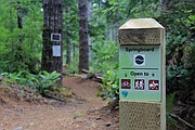
Riders have options for both an easier or more intermediate level loop.
I started with the easier loop - a good way to become accustomed to flow trails if you've never tried them.
From the trailhead, I followed Dutchman Trail on a gradual climb of 1.4 miles to BLM Road 36, where another easy mile brought me to the top of Springboard Trail. The climb was 580 feet.
This is where the fun begins. The trail swoops downhill and the difference between riding regular single track and a flow trail becomes obvious right off the bat.
With high-banked turns, you can swoop around corners without slamming on the breaks. In fact, brakes are optional here (so is pedaling), since the trail's collection of rolls and hills allow riders as much or as little speed as desired. The flow of Springboard Trail is 1.5 miles - it goes quick - the full loop is 4.4 miles.
The intermediate option, likely to lure more experienced mountain bikers, begins with a 3.6 mile and 995 foot climb up paved Fall Creek Road (just beyond the gate at the trailhead) to the top of High Baller Trail.
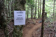
This stretch is a significant step up from the easier loop and you get a sense of what's to come from a sign attached to a tree that reads: "Danger: drops and roots oh my!"
True to form, the trail squeezes through narrow gaps, over roots and along a series of quick drops that will punish those not prepared (helpful signs warn riders before the drops). After 0.5 mile, the trail hits a flat spot. The lower section of High Baller is flow trail, with bigger turns, jumps and more speed possible on what's I'd consider the most thrilling stretch of the trail.
High Baller Trail connects to Springboard Trail and the easier stretch, eventually concluding a loop of 6.7 miles. There are signs and markers at every intersection, meaning getting lost is unlikely.
Overall, the High Baller and Springboard route is among the best mountain biking that I've experienced and a great start for the Alsea Falls Trail system. It will be fun to see where they take it next.
• If you go ...
Alsea Falls Trails System
In a nutshell: Six new miles of mountain bike-focused trails
Other attributes: The BLM recreation site also is home to a small campground and hiking trails that lead to 30-foot Alsea Falls and 60-foot Green Peak Falls. This is on the north side of paved South Fork Road.
Location: Between Alpine and Alsea southwest of Corvallis
Directions to trailhead: From Corvallis, head south on Highway 99W for 16 miles. Turn west on Alpine Road (which eventually becomes South Fork Road) a total of 13.5 miles, following signs for Alsea Falls. Past the campground entrance for Alsea Falls, continue a bit further and turn left on Fall Creek Road to a gate and the trailhead.
Easy/moderate Loop: Dutchman Trail, Forest Service Road 36, Springboard Trail, Dutchman Trail - 4.4 miles and 580 feet of climb
Intermediate Loop: Fall Creek Road, High Baller Trail, Springboard Trail, Dutchman Trail - 6.7 miles and 995 feet of gain.
ARTICLES BY ZACH URNESS/(SALEM) STATESMAN JOURNAL

Wider is better
Cruising Oregon Coast beaches on a fat bike
LINCOLN CITY, Ore. (AP) - It's difficult to say this, but there's a good chance my love of hiking Oregon Coast beaches is gone forever.

New mountain biking network in Coast Range
ALSEA, Ore. (AP) - The thing that struck me during a ride through Alsea Falls Trails System was how engineers had conjured something unique, maybe even beautiful, from an uninspiring canvas.
Hot springs offer warm respite from winter
SALEM, Ore. (AP) - If there's a better way to escape the rainy-day blues than a dip into the magic waters of Oregon's hot springs, I've yet to experience it.


