
Wildfires prompt closure of North Fork Cd'A River drainage area
Coeur d'Alene Press | UPDATED 11 years, 1 month AGO
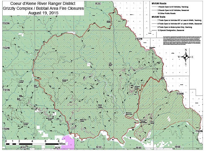
Large area of North Fork of Cd'A closed
Due to close to 20 individual fires burning on the Coeur d’Alene River Ranger District and forecasted hazardous fire weather, an area closure has been issued for a large portion of the North Fork Coeur d’Alene River drainage.
The closure is necessary for public safety concerns.
The closure encompasses the area generally east of Forest Roads 422, 812, 6749, 900 and 400 between Magee and Hwy 9; north of Hwy 9, Forest Roads 152, 2349 and 1551 between Forest Road 400 and the Idaho/Montana border; west of the Idaho/Montana border between Forest Road 1551 and Forest Road 992; and south of Forest Roads 992, 600, and 6310 between the Idaho/Montana border. This closure includes the length of the North Fork Coeur d’Alene River road between Shoshone Base Camp and Cinnamon Creek.
Additionally, the following recreational areas are closed:
· Devil’s Elbow Campground
· Big Hank Campground
· Kit Price Campground
· Shoshone Rest & Dump Station
· Pritchard Bridge Day Use
· Avery Creek Day Use
· Berlin Flats Campground
· Eagle Creek/ Settlers Grove Trailhead
· Big Long Pool Designated Dispersed
· Hawkseye Designated Dispersed
· Independence Designated Dispersed
· Clee Creek Day Use (CXT)
· Avery Creek Cabin
· Little Guard Lookout
· Spyglass Lookout & Ground House
For questions regarding reservations at any of the campgrounds, please visit http://www.recreation.gov/ or call (888) 448-1474. For questions regarding reservations at any of the rental cabins, please contact Barb Hansen at (208) 769-3050.
For a detailed look at the closure area please see the attached map, or visit the Idaho Panhandle National Forest’s Wildfire Emergency Closure webpage. Additionally, a fire information call center has been established at (208) 765-7383 and can provide information related to area wildfires and closures.