State of disaster declared by governor as flood worries persist
Kathleen Woodford Mineral Independent | Hagadone News Network | UPDATED 7 years, 8 months AGO
Gov. Steve Bullock declared a second executive order this month declaring a “disaster to exist in the state of Montana” on May 21. In the most recent declaration, Gov. Bullock stated that, “flood conditions persist and have worsened in many locations since I declared a state of emergency to exist statewide in Montana”. His previous order was on May 1, 2018.
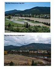
The National Weather Service has reported flooding ranging from minor impacts in agricultural areas and rural roads, to major impacts affecting homes, businesses, and major infrastructure in 38 locations across Montana. Also, in recent weeks, the State Emergency Coordination Center has received 11 additional declarations of emergencies from local and tribal jurisdictions throughout the state.
Significant flooding is expected to continue as temperatures warm and snow melts due to continued snowpack at higher elevations in the mountains of western and central Montana. The snowpack in Mineral County is at 132 percent of normal, and the upper Clark Fork is at 155 percent as of May 25.
May 28 was the day flood water would crest on the lower Clark Fork with predictions of 18.04 feet at St. Regis. The ‘action’ flood stage is considered at 19 feet with “major” flooding at 22 feet according to the National Weather Service. The St. Regis River is well below flood stage at 5.61 feet, where minor flooding is considered at 8 feet. There are no other reports of flooding in Mineral County where the river near Superior is below flood levels at 9.5 feet.
Another problem area is in Plains where the “minor” flood stage is predicted at 16.84 feet on Friday. Major flooding is considered at 19.5 feet. The water level on the Clark Fork River above Missoula rose to roughly 11 feet on Thursday, May 24 moving the river into moderate flood stage. The current forecasts predict the water will continue to rise and will remain in moderate flood stage for the rest of the week.
ARTICLES BY KATHLEEN WOODFORD MINERAL INDEPENDENT
Mineral County sends tax bill to Forest Service
The Forest Service will be receiving a property tax bill from Mineral County this year. County Commissioners Laurie Johnston, Roman Zylawy and Duane Simons signed the letter March 9 requesting property tax revenue for 2017. The “historic letter” as defined by Rep. Denley Loge, describes the plight Mineral County is facing as options to fund the county have dried up.
Colorado woman dies after vehicle gets stuck
An early evening call received by Mineral County dispatch on Friday, March 17, ended in tragedy. The body of Colorado resident Debra Ann Koziel was found in the Fish Creek area by a search team the following Tuesday afternoon. Her death was determined to be the result of exposure to weather.

No major flooding as snow thaws
“As the ground starts thawing, the rocks start falling,” was a post made on the Mineral County Sheriff’s Office’s Facebook page last week. A photo accompanied the post of a big rock which had come down on Mullan Road East near the Big Eddy fishing access in Superior on March 11. “Please be aware of your surroundings and pay attention while driving,” they warned in the post.


