Nature escapes, close to home
Jason Wilmoth For Coeur Voice | Hagadone News Network | UPDATED 6 years, 6 months AGO
This is the second of a two-parter on hiking trails in the Coeur d’Alene area. For the first, see the Coeur Voice page at Cdapress.com.
Q’emiln Park
I love Q’emiln (pronounced “Ka-Mee-Lin”) - it’s probably my favorite close-to-town spot.
I’ve explored the park over and over, descending into canyons and hiking over rocky outcroppings. I’ve found hidden caves dripping with moss, mines and worn away mining claim posts supported by rock piles, uplands covered in spring flowers. I’ve seen deer and elk, walked past giant moose in wetlands hidden amongst the thrust faults which created the features drawing rock climbers to the clean granite faces.
And with the City of Post Falls’ recent 300-acre acquisition, I’m no longer trespassing to hike and climb in the old out-of-bounds area. There are trails and a completely new parking area near the western end of the park.
For those who want to stay on the trail, there is a great three-mile loop which winds over the rocky uplands, near the abandoned Diamond Dick mine and across the pine forest below.
Access: To reach the main trailhead, take the Spokane Street exit in Post Falls and head south, soon crossing the bridge over the Spokane River. Take the next right, and drive straight back. You will come to a fee booth and an asphalt parking lot.
There is a new, secondary, parking area on W Riverview Drive. After you cross the Spokane River, keep going straight and veer right at the “Y” onto Riverview. From this point, continue west 1.5 miles and the trailhead for the Post Falls Community Forest will be on your right.
Difficulty: Easy to moderate, with trails designated by color-coded arrows. If you’re looking for something more than a leisurely jaunt, take a trails which heads into the highlands. Please keep my favorite park trash free!
Canfield Mountain
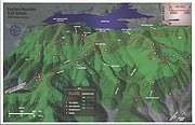
The Canfield Mountain trail system came into being after a large timber sale in the early ‘90s. As part of the rehabilitation with some funds from the timber sale, the U.S. Forest Service established multi-use trails crisscrossing the old forest roads.
There are two main access points, up Nettleton Gulch and along the paved road towards Fernan Saddle.
I’ve hiked these abandoned roads extensively but have only been to the summit once, snowmobiling to the top with friends. In fact, on the weekend you will probably encounter more motorcycles and mountain bikes than you will other hikers, but due to its proximity to Coeur d’Alene and the great views, these trails are well worth hiking. For the most part, the sound of dirt bikes on the mountain won’t intrude into your solitude and there is plenty of wildlife to be seen.
Access: From I-90 take the 15th Street exit in Coeur d’Alene and head north. At Nettleton gulch road take a right and drive up the valley into the National Forest, then up the dirt road to the trailhead at the first major switchback (about 2.5 miles from 15th Street). From here you can proceed in several different directions, either on single track (such as Cave Trail) or past the gate on the old dirt road.
The second trailhead is along the main road to Fernan Saddle, a popular access point for the Coeur d’Alene mountains. Take the Fernan exit off I-90 and head north, away from Coeur d’Alene, first driving along the shore of Fernan Lake. About six miles from the freeway look for the shooting range on your right. The trailhead will be on your left.
Difficulty: I rate these trails as moderate, as there is nothing obscenely steep or sustained.
Motorcycles, ATVs and mountain bikes are abundant at the Nettleton Gulch trailhead. While you are hiking, step off the trail when you see or hear them coming. They may not be watching for hikers. This area was intended for their use as well.
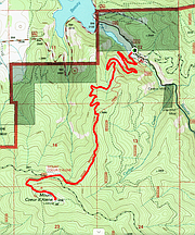
Mount Coeur d’Alene & Caribou Ridge
I’ve only done this trail once, and it was during a race. My uncles, Mike and Doug Bailey, asked me to do an adventure race with them - the NIC challenge. We paddled a canoe across Beauty Bay, then up into Wolf Lodge Creek. We ran up the road and grabbed mountain bikes then rode to the top of Mount Coeur d’Alene.
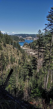
Trying to keep up with those two meant crashing multiple times on the downhill, and collapsing at the finish. I have heard from others (who were less sidetracked) that the trail is spectacular. The best views come on the way to the summit, well worth the roundtrip, 10-plus miles of trail.
The trail climbs steadily all the way to the top, although near the top you leave the trail and ascend an obviously overgrown road to the summit. Since the trail ascends over 2,300 hundred feet of switchbacks, I would be prepared for some Type 2 fun.
Access: From I-90 take the Wolf Lodge exit and turn right onto Highway 97. You will drive along the southern shore of the lake until you reach a small area of houses at Beauty Bay. First, pass the trailhead for Mineral Ridge on your left. Continue past, then before crossing the bridge, take a left turn and drive up Beauty Creek Rd.
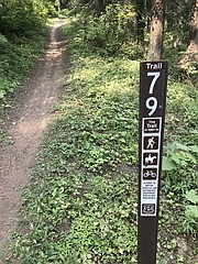
There are really two trails coming up out of this drainage, Trail 79 and Trail 257. Both climb towards Mount Coeur d’Alene, but Trail 257 does not achieve the summit itself, instead it must be combined with Trail 258.
Caribou Ridge Trail 79 reaches the summit at around 5 miles. Trails 257 and 258 can be combined for a roughly 12-mile loop.
The first trailhead, Caribou Ridge Trail 79, starts right at the Beauty Creek Campground, just a half mile up the road from. You will start off the hike by having to cross the creek, which may be sketchy in the spring runoff but is dry by summer. The second, Trail 257, is another 2 miles up the road. You will see a parking area on your left and the trail on your right.
Difficulty: Difficult, due to the long miles, as well as the sometimes strenuous uphill. There are several signs directing you, but it would be easy to take a wrong turn and end up somewhere other than the trailhead where you started at.
Enjoy the beautiful escape!
ARTICLES BY JASON WILMOTH FOR COEUR VOICE

Remembering Captain Wes: An authentic, kind life
I went to a workshop recently, the purpose of which was to discover your designed purpose.

A muddy trek into the past
I get the winter blues.

Nature escapes, close to home
This is the second of a two-parter on hiking trails in the Coeur d’Alene area. For the first, see the Coeur Voice page at Cdapress.com.


