
Kootenai River Complex fire update Sept. 14
EMILY BONSANT | Hagadone News Network | UPDATED 4 years AGO
I have deep North Idaho roots and graduated from Eastern Washington University with an English degree with a creative writing emphasis with a minor in film. I worked at at the Bonner County Daily Bee before coming to work at the Bonners Ferry Herald in August 2021. I enjoy writing for the paper that my great-grandfather read and covering the same small town community that is still alive today. I cover all things Badger sports, local politics and government, community news, business, outdoors and appear on the 7Bee podcast for the Herald's update. When I'm not working I can be found reading a good book and sipping tea, knitting or attempting to sign opera. | September 14, 2022 9:20 AM
BOUNDARY COUNTY — Air quality has been poor in Bonners Ferry the past few days due to smoke from the Kootenai River Complex fires and large fires in the western United States.
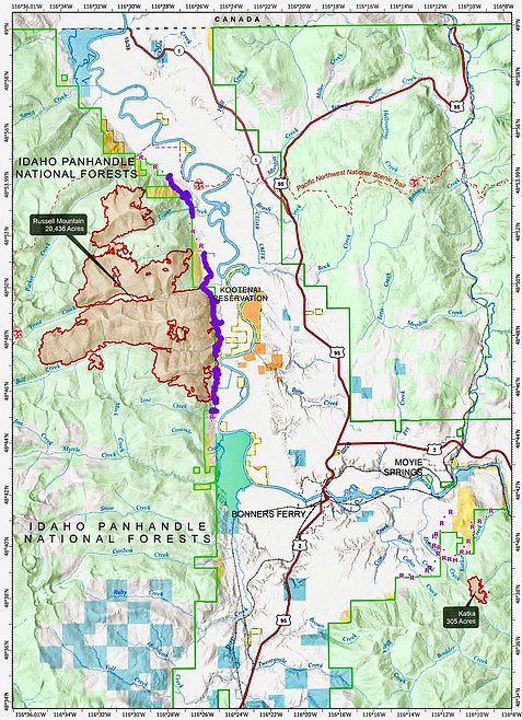
The Type 2 Northern Rockies Incident Management Team 4 is in command of the fire prevention efforts. As of the morning of Sept. 14, the fires are estimated at 20,742 acres in size, with 79 percent completion and 369 personnel.
Due to printing deadline any fire updates for Thursday, Sept. 15 will run online at www.BonnersFerryHerald.com.
The incident management team officers wrote in a press release that Kootenai River Complex fires are still producing smoke, but that other fires are also impacting the air quality in much of Idaho, Washington and Montana.
Air quality is represented by the air quality index and includes several major air pollutants including particle pollution, or particulate matter and is the principal public health threat from wildfire smoke. AQI of “unhealthy” to “hazardous” indicates increased risk for health effects after breathing polluted air.
While respirator masks can be effective in reducing exposure to smoke particles, surgical masks, dust masks and bandanas do not offer protection from particle pollution, incident management team officials wrote. Air quality monitors can be viewed at https://fire.airnow.gov.
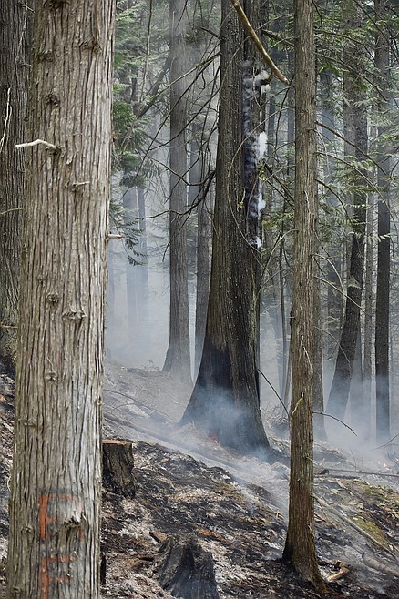
Smoke filled skies and light winds kept fire activity minimal throughout the day on Tuesday, officials said. The Katka and Russell Mountain Fires continue to burn as low intensity ground fire. Crews have thinned vegetation along Westside Road north of Trout Creek Road. On the east end of the Trout Creek Road, firefighters held the fire at the road so fire could back slowly downhill on the north side. South of Trout Creek Road to Ball Creek Road, crews continued to hold and suppress the fire as it reached the fireline and Westside Road.
The overnight infrared detection flight was able to fly over the fire area Tuesday night showing an increase in size of 1,034 acres.
Planned actions for Wednesday included, preparation to thin vegetation along parts of Westside Road. Officials said this is in preparation to make the roadside more defensible for when the fire reaches the area.
Crews continue to strengthen the fireline and run the pumps and sprinklers to make sure that the private structures are prepared for when the fire arrives. The fire is expected to continue backing downhill toward the Westside Road and fireline.
The Katka Fire will be monitored. Helicopters are available to be used for water delivery as needed however, smoke conditions might prevent flying like the past two days.
Tuesday morning Bonners Ferry and other parts of the county received rain. Thunderstorms took place in the morning.
Due to active fires and fire suppression activities, the Westside Road is restricted to residents-only. Additionally, the following National Forest Trails are now closed: Ball Creek Road (FR 432), Trout Creek Road (FR 634), Russell Mountain (No. 12), Russell Ridge (No. 92), Ball and Pyramid Lakes (No. 43), Pyramid Pass (No. 13), Pyramid Peak (No. 7), Fisher Peak (No. 27), Trout Lake (No. 41), McGinty Ridge (No. 143), Clifty Mountain and Clifty/Burrow (No. 182), Myrtle Peak Trail (No. 286), and Burton Peak Trail (No. 9).
Evacuations: There are NO Evacuations currently in place. However, those living on the Westside Road closest to Ball Creek, Burton Creek and Clark Creek have been placed in the SET fire evacuation status. SET is the stage of readiness before an actual evacuation takes place. Residents of Boundary County, Idaho can visit https://www.nixle.com or text their home zip code to 888777 to sign up for emergency alerts.
ARTICLES BY EMILY BONSANT

Bears, cider press, family fun, oh my!
Apples were pressed, and fresh cider flowed at the second annual North Idaho Bear Fair at the Boundary County Fairgrounds on Sept. 28.

One farm, one family, 100 years
Houck Farm celebrates a centennial of farming, family
Houck Farms has hit the centennial milestone and aims to continue growing and harvesting as they keep focused on a family creed, “If you take care of the farm, it will take care of you.”

Kokanee Coffee moves to Bonners, still serving coffee and the Lord
Kokanee Coffee, a familiar regional coffee house, has moved to a stand in Bonners Ferry, offering excellent coffee, food and the love of Christ.