As Sunset Fire grows, evacuations expand
CAROLINE LOBSINGER | Hagadone News Network | UPDATED 7 months AGO

A helicopter drops a bucket of water on the Sunset Fire in southern Bonner County on Friday.
Photo courtesy ERIC VALLIQUETTE/Idaho Department of Lands

Sunset access to the Sunset Fire is gained via boat on Friday.

A screenshot of an Idaho Department of Lands map shows the perimeter of the 2,700-acre Sunset Fire.
I grew up in the Tri-Cities, Wash., and have always loved to write. I attended the University of Washington, where I earned a double major in journalism and political science, with an area of emphasis in history. I am the fifth out of six kids — don't believe any of the stories that my siblings tell. To be able to tell others stories and take photos for a living is a dream come true — and I considered myself blessed to be a community journalist. When I am not working, I enjoy spending time with family and friends, hiking and spending time outdoors, genealogy, reading, and watching the UW Huskies and the Seattle Seahawks. I am a servant to my cat, Frankie, who yes, will eat anything and everything in sight … even wedding cookies. | August 15, 2025 8:42 PM
SANDPOINT — The Sunset Fire continues to grow as do the number of evacuations associated with the fire, now estimated at 2,702 acres.
Most activity is occurring along the fire’s northern perimeter, where Hotshot crews and aerial resources are working to build firelines to slow its advance, Idaho Department of Lands officials said Friday evening.
Since being reported Wednesday evening, the fire has grown rapidly. Within several hours, it expanded from a half-acre to more than 50 acres, then nearly 700 acres. By Thursday, the fire had more than doubled, and Friday, it grew by more than 1,000 acres throughout the day.
The Idaho Panhandle Hotshot crew, previously assigned to the Lightning Creek Fire north of Clark Fork, was reassigned to the Sunset Fire north of Athol. Several other assets, including a wildland fire engine, were also reassigned to the fire in southern Bonner County.
“In the world of fire logistics, their need was greater,” said Kory Johnson, fire information officer for the Lightning Creek Fire.
The Sunset Fire continues to burn in heavy timber and steep terrain along the shore of Lake Pend Oreille, stretching from north of Bayview and Athol to Little Blacktail and Blacktail mountains. Along the fire’s southern flank, crews are working to strengthen dozer lines and have begun installing hose lays to provide water at the fire’s edge. Night crews will continue those line-building efforts, IDL officials said.
Currently, 295 personnel are assigned to the fire. A complex incident management team is expected to arrive Saturday afternoon and begin shadowing the current incident organization before taking command.
Additional resources have been assigned to the fire, including helicopters, air tankers, air attack planes and scoopers.
Structures and other values at risk remain threatened. Structure protection groups and local firefighters are continuing to assess areas along Talache Road and Butler Creek. Additional crews are expected to support work in the area, officials said.
Evacuations in southern Bonner County continue to expand. All residences east of East Dufort Road and on Talache Road — including all side streets — are under GO status, meaning residents should leave immediately.
Also under GO status are residents on Raven Road, Crosswhite Road, Little Blacktail Road, and east of 2268 Sunset Road. U.S. Forest Service Road 630 off Blacktail Road (north of Blacktail), Butler Creek and Butler Creek Spur — from Mirror Lake diagonally down to USFS 630 — including Five Lakes Estates, Jupline Landing, the entire Ponderosa neighborhood and everything south of Talache Road, are also included.
SET notices are in effect for homes on Blacktail Road a quarter-mile north of Little Blacktail, and everything north of Talache Road in Sagle. Residents should be prepared to leave at a moment’s notice.
READY advisories remain in place for all residents on Blacktail Road north of the quarter-mile mark and for the community of Bayview in neighboring Kootenai County.
An evacuation center has been opened at Cocolalla Bible Camp to assist displaced residents, in addition to an initial center opened by the American Red Cross at Sagle Elementary. The Bonner County Fairgrounds is available to shelter evacuated livestock on a limited basis.
The Better Together Animal Alliance is supporting Red Cross efforts to keep families and pets together by providing crates, food, litter, litter boxes and other pet supplies. The organization has also activated its Home to Home Emergency Response Program, which helps families locate temporary care for their pets.
The Idaho Transportation Department has temporarily lowered the speed limit to 55 mph on U.S. Highway 95 between Granite Hill and Blacktail Road to support firefighting efforts and public safety.
The cause of the Sunset Fire remains under investigation.
Near Clark Fork, the Lightning Creek Fire continues to show low activity, with creeping and smoldering in isolated areas. The fire remains at about 2,482 acres, with 138 personnel assigned, including five engines, a water tender, eight excavators, a feller buncher, two chippers and a hand crew.
“Firefighters continue to focus efforts on Lightning Creek Road, preventing the fire from spreading toward communities,” Johnson said.
Despite a heat advisory and gusty winds Thursday, Johnson said fire activity remains low, though a few hotspots persist. Firefighters continue improving Lightning Creek Road as a control line by cooling hotspots, cutting and hauling hazard trees, and chipping brush.
Containment remains steady at 10%, with the contained area along Lightning Creek Road.
“While much of the fire edge shows little fire activity, fire officials are unlikely to greatly increase the containment percentage in the near term because firefighters cannot safely access the entire fire perimeter due to hazard trees to ‘cold trail,’” Johnson said.
Cold trailing is when firefighters carefully inspect and feel for heat to detect any fire, digging out and extinguishing every sign of heat.
An area closure order is in place surrounding the fire. Lightning Creek Road (Forest Service Road 419) is closed from the junction of Trestle Creek Road (FSR 275) south to the Regal Creek crossing. The closure is necessary to protect public safety and ensure safe firefighting access.
A temporary flight restriction is in place for both the Sunset and Lightning Creek fires, prohibiting all drones and aircraft from operating in those areas without permission. Unauthorized aircraft pose a serious hazard to aviation personnel, forcing the grounding of aircraft and potentially delaying fire suppression efforts.
Information: Lightning Creek Fire: bit.ly/4l5NhIB, Sunset Fire: bit.ly/45EwwP9
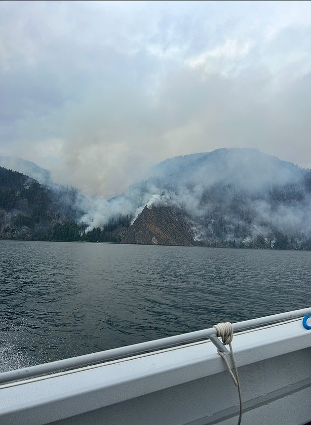 Sunset access to the Sunset Fire is gained via boat on Friday.
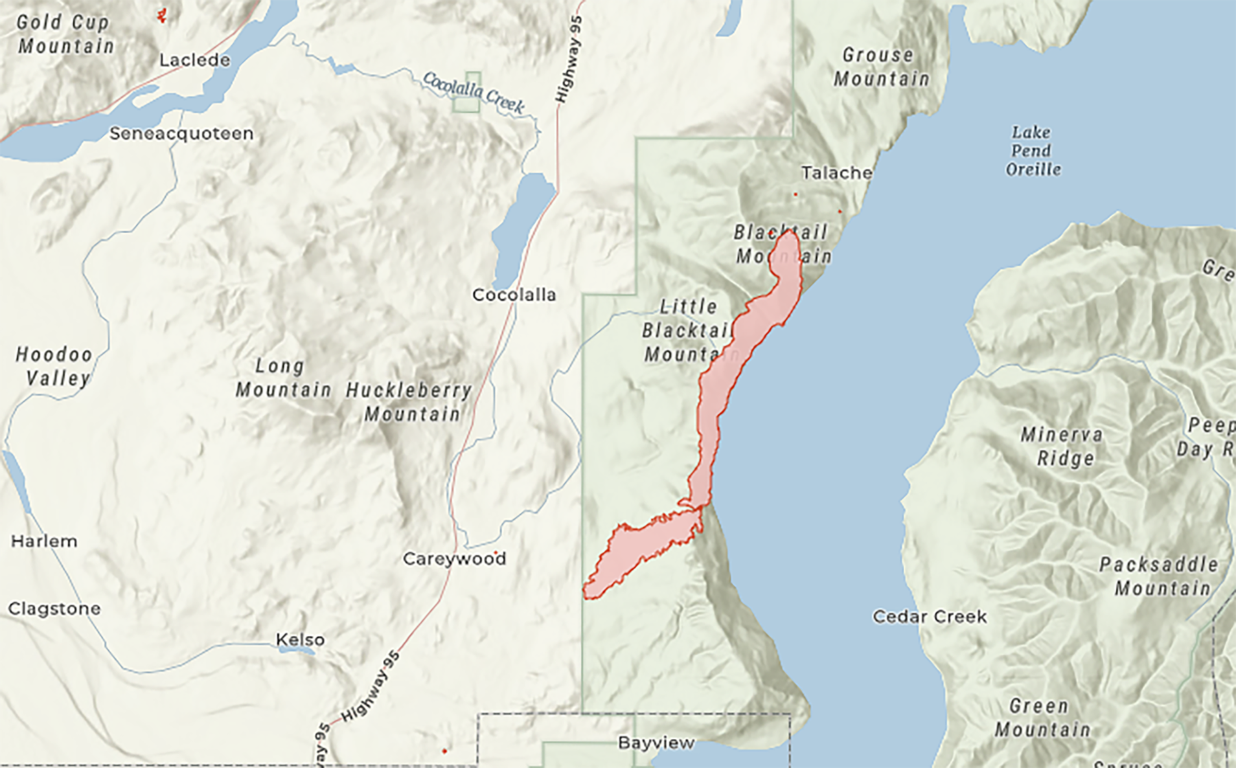 A screenshot of an Idaho Department of Lands map shows the perimeter of the 2,700-acre Sunset Fire.
ARTICLES BY CAROLINE LOBSINGER

Sandpoint warns of invoice scam attempt
Latest attempt target Planning Division customers
A renewed scam is circulating in Sandpoint, with fraudulent emails seeking payments tied to development applications.
Sandpoint warns of fake invoice scam
Latest attempt target Planning Division customers
A renewed scam is circulating in Sandpoint, with fraudulent emails seeking payments tied to development applications.

SHS students help food bank feed community
Empty Bowl fundraiser raises more than $5,000
Art Students Help Feed Community Through Empty Bowl Event