Sunset Fire more than doubles in size
CAROLINE LOBSINGER | Hagadone News Network | UPDATED 4 months AGO


I grew up in the Tri-Cities, Wash., and have always loved to write. I attended the University of Washington, where I earned a double major in journalism and political science, with an area of emphasis in history. I am the fifth out of six kids — don't believe any of the stories that my siblings tell. To be able to tell others stories and take photos for a living is a dream come true — and I considered myself blessed to be a community journalist. When I am not working, I enjoy spending time with family and friends, hiking and spending time outdoors, genealogy, reading, and watching the UW Huskies and the Seattle Seahawks. I am a servant to my cat, Frankie, who yes, will eat anything and everything in sight … even wedding cookies. | August 15, 2025 1:00 AM
More residents in southern Bonner County have been ordered to evacuate due to the growing Sunset Fire northeast of Athol.
In the past 24 hours, the Sunset Fire has doubled in size — now estimated at 1,600 acres — consumed three structures and forced the evacuation of numerous residents, with more announced Thursday evening.
“Values at risk continue to be threatened, and fire crews are assessing structures and implementing point protection where possible,” said Jennifer Russell, fire information officer for the North Idaho Type 3 Incident Management Team. The team, led by Mike McManus, assumed command of the fire Thursday afternoon.
Idaho Department of Lands officials said the fire is moving northeast and exhibiting extreme behavior, with short crown runs through timber. While air resources are dropping water and retardant, dense smoke has at times limited aviation operations.
Air and ground crews continue to engage the fire directly where it is safe to do so, with firefighter and public safety the top priority, Russell said.
Evacuation orders remain in place for residents on Raven, Crosswhite and Little Blacktail roads, as well as those living east of 2268 Sunset Road. Residents in these areas are on “Go” status, meaning they should leave immediately.
Officials expanded the evacuation order Thursday afternoon to include residents on U.S. Forest Service Road 630 off Blacktail Road (north of Blacktail), Butler Creek and Butler Creek Spur, from Mirror Lake diagonally down to USFS 630. This includes Five Lakes Estates, Jupline Landing, the entire Ponderosa neighborhood and everything south of Talache Road.
“Go” status is the final stage of the Ready-Set-Go evacuation protocol. “Ready” means residents should have an evacuation plan. “Set” means they should begin implementing that plan.
“Set” notices are in effect for residents on Blacktail Road living a quarter-mile north of Little Blacktail and everything north of Talache Road in Sagle. Residents should be prepared to leave at a moment’s notice.
“Ready” advisories remain for all residents on Blacktail Road north of the quarter-mile mark and for the Bayview community in neighboring Kootenai County.
While weather conditions have improved since Wednesday evening’s high winds — thanks to cooler temperatures and lighter gusts — steep terrain and limited road access continue to challenge firefighters. Officials are urging the public to avoid the fire area and respect road closures.
Additional resources have been assigned to the fire, including helicopters, air tankers, air attack planes and scoopers.
Selkirk Fire Chief Jeff Armstrong said firefighters have been working hard to battle the blaze and noted they were fortunate the fire started where it did, with wind and topography pushing it away from more populated areas.
“I’m proud of our firefighters and the coordination with IDL,” Armstrong said. “While some structures were lost, many more were saved.”
Armstrong emphasized that the incident is far from over and said local firefighters will continue to support IDL crews and their communities “in any way we can.”
In addition to an evacuation center at Sagle Elementary, another has been opened at the Cocolalla Bible Camp to assist displaced residents. The Bonner County Fairgrounds are available to shelter evacuated livestock on a limited basis.
The Idaho Transportation Department temporarily lowered the speed limit to 55 mph on U.S. Highway 95 between Granite Hill and Blacktail Road to support firefighting efforts and public safety.
“Fire crews are staging equipment in the area, and evacuations are taking place as part of the emergency response,” ITD officials said in a news release. “Idaho State Police will have troopers patrolling the area to make sure drivers follow the reduced speed limits, helping ensure the safety and efficiency of fire operations.”
The cause of the Sunset Fire remains under investigation.
Near Clark Fork, the Lightning Creek Fire saw minimal activity, with creeping, smoldering and backing in isolated areas, said Kory Johnson, U.S. Forest Service fire information officer, in a Thursday news release.
“Firefighters continue to focus efforts on the Lightning Creek Road, preventing the fire from spreading toward communities,” Johnson said.
Wednesday’s warm weather and gusty winds only minimally increased fire activity. Johnson said most of the Lightning Creek Fire area is showing minimal heat, concentrated in isolated areas adjacent to the fire line, as the fire continues to burn within the 2018 Cougar Fire footprint.
“The Cougar Fire left behind a large, continuous area of fire-weakened dead trees, which are now falling,” Johnson said. “Much of the burned area is unsafe for firefighters due to these falling trees.”
A drone flight confirmed minimal heat and fire activity, which is expected to decrease further with cooler temperatures and increased moisture.
Located nine miles north of Clark Fork, the fire is 2,481 acres and 10% contained. There are 142 personnel assigned to the fire, including five engines, a water tender, eight excavators and a hand crew.
An area closure order is in place surrounding the fire. Lightning Creek Road (Forest Service Road 419) is closed from the junction of Trestle Creek Road (FSR 275) south to the Regal Creek crossing. The closure is necessary to protect public safety and ensure safe firefighting access.
A temporary flight restriction is in place for both the Sunset and Lightning Creek fires, prohibiting all drones and aircraft from operating in those areas without permission. Unauthorized aircraft pose a serious hazard to aviation personnel, forcing the grounding of aircraft and potentially delaying fire suppression efforts.
Information: Lightning Creek Fire: bit.ly/4l5NhIB; Sunset Fire: bit.ly/45EwwP9
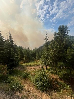 Smoke from the Sunset Fire can be seen in southern Bonner County.
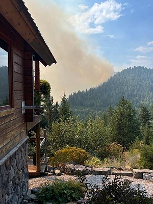 Smoke from the Sunset Fire can be seen in southern Bonner County.
ARTICLES BY CAROLINE LOBSINGER

'Tots' aims to make holidays bright
Help the Sandpoint Lions reach their $75,000 goal for Toys for Tots.

USACE keeping eye on region's flood risk
U.S. Army Corps of Engineers said they are managing rising Lake Pend Oreille and Libby Dam outflows amid heavy rains and atmospheric rivers.
'Tots' creates special Christmas memories
Help the Sandpoint Lions reach their $75,000 goal for Toys for Tots.