
Crews hold Sunset Fire in check at 3,208 acres
CAROLINE LOBSINGER | Hagadone News Network | UPDATED 1 year, 2 months AGO
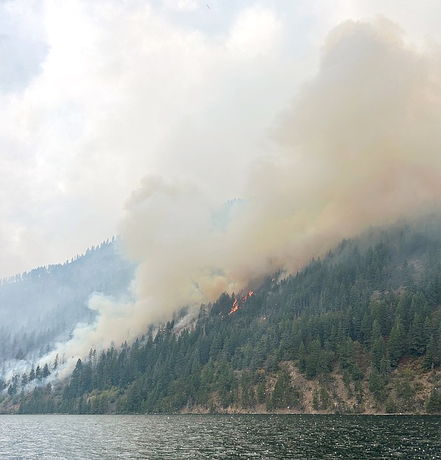
A view of the Sunset Fire from a fireboat en route to assist ground forces protecting values at risk along the shoreline of Lake Pend Oreille in southern Bonner County.
Photo courtesy IDAHO DEPARTMENT OF LANDS
I grew up in the Tri-Cities, Wash., and have always loved to write. I attended the University of Washington, where I earned a double major in journalism and political science, with an area of emphasis in history. I am the fifth out of six kids — don't believe any of the stories that my siblings tell. To be able to tell others stories and take photos for a living is a dream come true — and I considered myself blessed to be a community journalist. When I am not working, I enjoy spending time with family and friends, hiking and spending time outdoors, genealogy, reading, and watching the UW Huskies and the Seattle Seahawks. I am a servant to my cat, Frankie, who yes, will eat anything and everything in sight … even wedding cookies. | August 21, 2025 1:00 AM
SANDPOINT — Crews of the Sunset Fire again held the wildfire in check, keeping acreage burned to 3,208 acres.
Flanking and torching behavior were expected to increase Wednesday in areas with isolated residual heat as heavy fuels continue to burn. As fuels continue to dry, higher temperatures and lower relative humidity will result in increased potential for fire activity, Northern Rockies Team 5 officials said.
Hotshots, Type 2 hand crews, engines, and heavy equipment are working to improve and strengthen fire lines along the fire's western flank, while hotshot and Type 2 hand crews work to establish fire lines on its northern flank.
Aerial resources, including scoopers and helicopters, are dropping water on the fire's southern, western, and northern flanks to support firefighters on the ground, Northern Rockies officials said.
In addition, structure protection teams continue efforts to implement protection measures where needed in the Talache Road and Butler Creek area. From the lakeshore, watercraft will insert crews into remote areas.
Northern Rockies crews said crews are using daytime infrared flights, flown at 18,000 feet, to locate heat pockets as well as drones with infrared capabilities to search for potential hot spots and residual heat.
As the weather warms up and conditions dry, fire officials said smoke from the fire will likely be more visible in the surrounding area. Temperatures are expected to climb to the mid-80s with light and variable winds. High pressure over the Rockies will continue a drying and warming trend and bring the potential for much warmer temperatures and dryness by the weekend.
Water scoopers are continuing to draw water from Lake Pend Oreille. Boaters are reminded to stay out of the flight path of these planes to minimize disruptions to firefighting efforts.
In Bonner County, residents on Raven, Crosswhite and Little Blacktail roads, as well as those living east of 2268 Sunset Road have been asked to evacuate from their homes. Also on "GO" status are residents on U.S. Forest Service Road 630 off Blacktail Road (north of Blacktail), Butler Creek and Butler Creek Spur, from Mirror Lake diagonally down to USFS 630. This includes Five Lakes Estates, Jupline Landing, the entire Ponderosa neighborhood and everything south of Talache Road.
An evacuation center has been opened at the Cocolalla Bible Camp to assist displaced residents. The Bonner County Fairgrounds is available to shelter evacuated livestock on a limited basis.
Northern Rockies Team 5's incident management team is working with the Bonner County Sheriff's Office to clarify the narrative descriptions of the evacuation zones for the Sunset Fire.
A temporary flight restriction is in place over the Sunset Fire, prohibiting all drones and aircraft from operating in those areas without permission. Unauthorized aircraft pose a serious hazard to aviation personnel, forcing the grounding of aircraft and potentially delaying fire suppression efforts.
Area closures are in effect on the Idaho Panhandle National Forests. The area closure encompasses all National Forest System lands along the western shoreline of Lake Pend Oreille, from Camp Bay south to Three Sisters Horizontal Control Station. The closure extends west to Three Sisters Creek, then proceeds north to just south of National Forest System Road 230. The closure area then follows a stepped northeast path to Hickman Creek continuing east to the forest boundary and then heads north to Sagle Road. From Sagle Road, the boundary extends east back to Camp Bay.
Near Clark Fork, the Lightning Creek Fire has burned an estimated 2,515 acres and is about 25% contained. The fire, located nine miles north of the city, is burning through heavy dead and down fuels left from the 2018 Cougar Fire.
Fire activity is minimal with isolated creeping and smoldering. Control lines along Lightning Creek Road remain secure and are being reinforced, Sandpoint Ranger District officials said Wednesday.
The fire was turned over to the ranger district on Monday, and firefighting efforts are being managed by Incident Commander Kelly Tucker.
Information: Lightning Creek Fire: bit.ly/4l5NhIB; Sunset Fire: bit.ly/3V8GGm7; Bonner County Sheriff's Office, bonnerso.org
ARTICLES BY CAROLINE LOBSINGER

Wellness fair puts focus on health
The Wellness & Connection Fair is bringing together local health and wellness professionals together in Sandpoint for a day of presentations, activities and community resources.

BCSD pays share of ISBT shortfall
District opts to make lump sum payment
Boundary County School District paid $217,000 to cover its share of the Idaho School Benefit Trust's $13 million shortfall.

Deadline extended for 'Valor' stories
The Valor publication is gathering photos, military service details and personal stories from Boundary County veterans and military families. Featured profiles highlight local service members' contributions, achievements and sacrifices across generations.