Historic rain floods areas of Lincoln County
MATT BALDWIN | Hagadone News Network | UPDATED 3 months, 2 weeks AGO

The bridge over Farm to Market Road south of Libby washed out early Thursday morning, Dec. 11, 2025, after days of rain and warm temperatures caused extensive flooding in south Lincoln County. (Scott Shindledecker/The Western News)

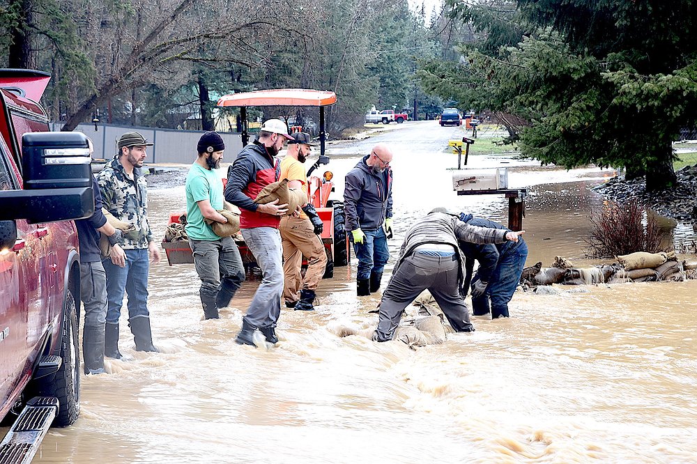
Residents place sandbags at Cherry Creek in Lincoln County,Mont., on Thursday.
Hagadone Media Montana REGIONAL MANAGING EDITOR Matt Baldwin is the regional editor for Hagadone Media Montana, where he helps guide coverage across eight newspapers throughout Northwest Montana. Under his leadership, the Daily Inter Lake received the Montana Newspaper Association’s Sam Gilluly Best Daily Newspaper in Montana Award and the General Excellence Award in 2024 and 2025. A graduate of the University of Montana School of Journalism, Baldwin has called Montana home for nearly 30 years. He and his wife, Sadie, have three daughters. He can be reached at 406‑758‑4447 or [email protected]. IMPACT: Baldwin’s work helps ensure Northwest Montana residents stay connected to their communities and informed about the issues that shape their everyday lives. | December 11, 2025 10:10 AM
Widespread flooding in Lincoln County washed out bridges and swamped some roadways and neighborhoods around Libby on Thursday, prompting officials to issue emergency travel restrictions.
The sheriff’s office requested “necessary travel only” countywide because of the risk of flooding and mudslides.
Excessive rainfall combined with snowmelt caused the Yaak River near Troy to rise by roughly 5 feet over the last two days. The river was at 8.2 feet Thursday morning, above the 8-foot flood stage.
The Fisher River near Libby had risen about 4 feet since Monday and was at 6.8 feet Thursday morning. It was expected to hit minor flood stage at 7.6 feet by the afternoon.
A flood watch was issued for all of Northwest Montana through Thursday afternoon. Gov. Greg Gianforte said the Montana Department of Emergency Services had deployed resources to assist local first responders.
Videos and photos posted to social media showed the Granite Creek bridge on Big Cheery Creek washed out south of Libby, and Flower Creek, which runs through Libby, swollen above its banks.
Power outages were affecting hundreds of Flathead Electric Cooperative customers south of the city.
The Montana Department of Transportation reported closures on U.S. 2 between Libby and Kalispell, as well as Montana 56 between Libby and Noxon because of water on the roadways. Other secondary roads across the county were closed as well.
Troy School District canceled classes Thursday because of the flooding.
An atmospheric river has blasted the Pacific Northwest with intense rain and mountain snow since Sunday.
The Cabinet Mountains had received more than a foot of water equivalent over the last six days. The weather station at Poorman Creek south of Libby reported 5 inches of precipitation over the last 24 hours.
“Which is incredible,” commented National Weather Service meteorologist Dave Noble. The 24-hour total is the third most all-time for the location.
The historic weather system started as snow and transitioned to heavy rain earlier in the week, a recipe for flooding.
“The atmospheric river trended northward and was pointed right at Northwest Montana yesterday and today,” Noble said.
The train of moisture was predicted to waver Thursday, he said, but area mountains could see another inch of precipitation by Friday.
 Residents place sandbags at Cherry Creek in Lincoln County,Mont., on Thursday.
ARTICLES BY MATT BALDWIN

PHOTOS: No Kings protest draws crowd to Whitefish
A No Kings protest against the Trump administration drew hundreds of people to Grouse Mountain Fields in Whitefish on Saturday, March 28, 2026. The event, hosted by Flathead Democracy, was one of thousands held across the U.S., according to national event organizers.

Avalanche danger high after 2 to 3 feet of new snow
Dangerous backcountry conditions prompted a special avalanche warning Friday morning after Northwest Montana mountains were buried in 2 to 3 feet of snow.
Avalanche danger high after 2 to 3 feet of new snow
Dangerous backcountry conditions prompted a special avalanche warning Friday morning after Northwest Montana mountains were buried in 2 to 3 feet of snow.