Historic winter floods wipe out bridges, set off mudslides
TRACY SCOTT, AMY QUINLIVAN, SCOTT SHINDLEDECKER, JOSH MCDONALD Hagadone News Network | Valley Press-Mineral Independent | UPDATED 1 day, 8 hours AGO

A rock and mudslide damaged a garage on Eagle View Lane in Sanders County on Dec. 11, 2025. (Tracy Scott/Valley Press)

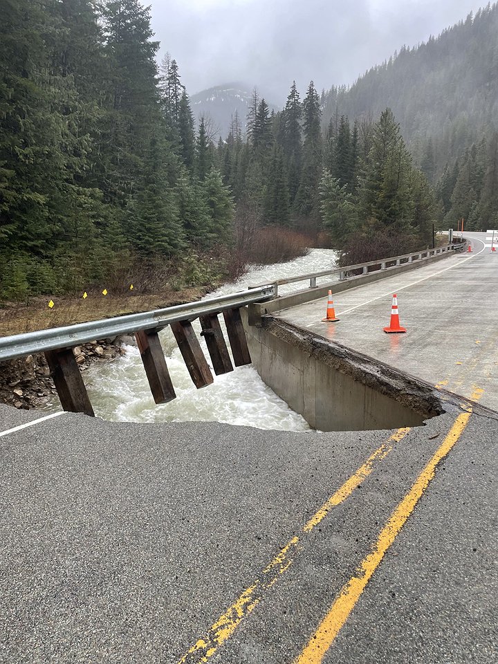
Highway 471 near Prospect Creek was closed Dec. 12, 2025 due to flooding. (Tracy Scott/Valley Press)

Highway 471 near Prospect Creek was closed Dec. 12, 2025 due to flooding. (Tracy Scott/Valley Press)

Floodwaters hit the Prospect Creek Bridge in Sanders County on Dec. 12, 2025. (Tracy Scott/Valley Press)

Highway 471 near Prospect Creek was closed Dec. 12, 2025 due to flooding. (Tracy Scott/Valley Press)

A rock and mudslide damaged a garage on Eagle View Lane in Sanders County on Dec. 11, 2025. (Tracy Scott/Valley Press)

This section of Prichard Creek Road has much of its base layer washed out due to fast-moving floodwater crashing against it. (Josh McDonald/Shoshone Press)

Workers removed a large pileup of trees and rootwods on December 11, which were washed downstream along the St. Regis River after several inches of rain. (Mineral Independent/Amy Quinlivan)

The river was inching very close to the Exit 33 off-ramp at St. Regis last week. The St. Regis River recorded higher flow rates three times higher flow rates than average spring runoff levels following a week's worth of December rainfall. (Mineral Independent/Amy Quinlivan)

Volunteers place sandbags where Cherry Creek flooded south of Libby Thursday, Dec. 11, 2025. (Scott Shindledecker/The Western News)

A property on Chase Cutoff was experiencing flooding from Lake Creek Thursday, Dec. 11, 2025, after days of rain and warm temperatures in south Lincoln County. (Scott Shindledecker/The Western News)

The bridge over Farm to Market Road south of Libby washed out early Thursday morning, Dec. 11, 2025, after days of rain and warm temperatures caused extensive flooding in south Lincoln County. (Scott Shindledecker/The Western News)

Floodwaters hit the Prospect Creek Bridge in Sanders County on Dec. 12, 2025. (Tracy Scott/Valley Press)

A rock and mudslide damaged a garage on Eagle View Lane in Sanders County on Dec. 11, 2025. (Tracy Scott/Valley Press)
| December 16, 2025 11:05 PM
An historic atmospheric river pummeled Northwest Montana and North Idaho last week as flooding washed out numerous bridges and roads across the region.
The Cabinet Mountains received more than a foot of water equivalent over six days. The weather station at Poorman Creek south of Libby reported 5 inches of precipitation on Dec. 11 alone.
“Which is incredible,” commented National Weather Service meteorologist Dave Noble. The 24-hour total is the third most all-time for the location.
The historic weather system started as snow and transitioned to heavy rain earlier in the week, a recipe for flooding.
Sanders County
Snowmelt combined with heavy rainfall led to flooding along the Bull River in western Sanders County.
“Side roads and small streams are what’s giving us the most trouble right now,” said Bill Naegeli with the Sanders County Office of Emergency Management on Friday. “Highway 56 near the Bull River Guard Station area and Eagle View Lane are our main concerns at this time.”
Eagle View Lane experienced extensive damage due to floodwaters, while a major rock and mudslide destroyed a garage along upper Eagle View Lane.
Naegeli stressed that motorists should use extreme caution when encountering water on roadways.
“Check before you drive through standing water, and if you pull off the roadside, make sure it’s a solid area,” he said. “The shoulders are very soft right now. There’s been a lot of water and no frost in the ground.”
Another area of concern was Highway 471, Thompson Pass Road, near Thompson Falls. At approximately mile marker 17, the bridge crossing Prospect Creek was washed out, leaving a large gap in the roadway.
Naegeli encouraged county residents to sign up for the Hyper-Reach app, a mass notification system designed for public safety emergencies. The app allows emergency officials to send alerts and updates directly to residents’ mobile devices. Residents in need of sandbags can contact the Sanders County Office of Emergency Management at 406-827-6955.
Naegeli also noted that dams along the Clark Fork River were being monitored, but no issues had been reported.
Mineral County
The atmospheric river event last week inundated area streams, spilled over the banks of local rivers, and damaged some bridges around the region.
After celebrating an early December opening of the slopes at Lookout Pass Ski Area, officials suspended operations last weekend following a near-historic 8 inches of rain on the pass. Haugan also received around 4 inches of rain on top of recent snowfall, leaving the grounds saturated and brown.
The rain event severely damaged the Deer Creek Bridge on the Superior Ranger District. This bridge is located near DeBorgia and is frequently used by snowmobilers and other winter enthusiasts during the wintertime. A closure order for the area was expected to be in place soon and the Forest Service asked people to avoid the area.
Downstream in St. Regis and impressive 2.88 inches of rainfall was recorded over the six-day storm last week. According to the USGS monitoring station located on the bridge heading up the Little Joe road, flow rates recorded a jump higher than normal spring runoff measurements.
On May 4, the St. Regis River peaked at 1,740 cubic feet per second, compared to the river’s cresting on Dec. 11 following the atmospheric river at 4,880 cfs. That is nearly three times higher than the spring runoff flow.
Lincoln County
For 12 very long hours, the residents of Libby and Troy weren’t sure whether the flood waters affecting south Lincoln County would abate.
Despite the many bridge and road washouts in the region, water levels began subsiding by late afternoon Dec. 11.
It was the worst flooding the area had seen since February 1996. Officials expect the cost of the damage to run into the tens of millions of dollars.
Lincoln County Sheriff Darren Short briefed the community Friday morning on the extent of the flooding as well as what local and state officials were doing in the aftermath.
Short said the flooding would be a long-term event for residents.
“Fortunately, we’ve had no fatalities or injuries. We are still waiting for the water to go down so we can properly access the damage to the bridges that are lost and those that are compromised,” Short said. “It could take months before we really know how much damage has occurred considering the remote location of some of the roads, including those on Forest Service lands.
“The financial part will be a tremendous drain for the county,” he added.
Short recounted the ordeal of a man who drove off the Libby Creek Bridge on Farm to Market Road as he headed to work early Thursday morning.
“The bridge was compromised when he drove off it, but he was able to make it out of the truck to safety,” Short said.
Bridges, including Libby Creek, were discussed at length. It was one of several washed out or compromised. The Sheriff’s Office reported other washed out bridges, including the Granite Creek bridge on Big Cherry Creek and the Keeler Creek Bridge. A bridge on Ross Creek Road near Bull Lake was also compromised.
Portions of Libby Creek Road and the Champion Haul Road were washed out as well.
The Fifth Street bridge in Libby that spans Libby Creek was closed Thursday and Friday morning. Libby Volunteer Fire Chief Steve Lauer said an inspection was made Friday and the bridge reopened that afternoon.
But orange pylons marking damage bordered some sections of the street where water had washed out the ground underneath the asphalt.
Short asked people to avoid these areas because of the hazards that still exist.
“The ground is not very stable and some of the road edges have been undermined, so these can still be places where accidents can occur or people can fall,” he said. “And you definitely don’t want to end up in the water now.”
State bridge inspectors were also on scene Friday to determine the status of the structures.
On Saturday, Lincoln County Emergency Operations addressed concerns about the Lower Flower Creek Dam near Libby. A low spot on the earthen embankment was breeched for roughly 12 hours Dec. 11, which resulted in moderate damage to the dam.
“At this time, the Lower Flower Creek Diversion Dam does not appear to be at risk of imminent failure,” the agency stated in a press release. “The site will continue to be closely monitored.”
If conditions change, the release stated, response team are prepared to intervene with heavy equipment.
There are no concerns with the larger Flower Creek Dam upstream, the agency state.
“There are no signs of damage, it is intact and is in great shape,” Short said at a town hall in Libby on Saturday.
The older reservoir, which is located 1 1/2 miles from Libby, is heavily silted. Short said that would slow the flow if the dike failed.
He said a Type 3 Incident Team from the western region would be coming to help manage response efforts.
The Red Cross emergency shelter was moved Saturday from the Assembly of God Church in Libby to the Memorial Center because of concerns that if the dike on the lower reservoir failed, flood waters could reach that side of town.
Gov. Greg Gianforte planned to attend Friday’s briefing, but foggy conditions prevented his plane from arriving.
“We’re thinking of you and we’re thankful to all of you for your work and response to this,” Gianforte said. “The White House is aware of the situation, too.”
The governor also pointed out that when certain dollar amounts are met, it will trigger federal help for replacement.
Despite the rising water, there were several scenes of neighbors helping each other, filling and stacking sandbags to safeguard homes and properties.
Nearly half a foot of rain fell in three days, which coupled with melting snow from the Cabinet Mountains to cause the flooding. Short remarked how unusual it was for this time of year.
“I’ve never seen anything like it going into winter,” Short said.
In Libby, city officials ordered a boil water advisory after its public water supply experienced high water turbidity due to the flooding. The order remained in effect Saturday and residents were advised to boil water for at least one minute before use for drinking, cooking, brushing teeth or washing dishes.
Shoshone County
Thursday’s historic flooding left lasting effects across the Silver Valley.
Conditions worsened quickly as high temperatures and heavy rain melted recent snow in the higher elevations, swelling tributaries and flooding much of the Coeur d’Alene and St. Joe rivers.
Along the North Fork Coeur d’Alene River, concerns over two key areas prompted Shoshone County commissioners to declare a state of emergency Thursday afternoon. Those areas included sections of Prichard Creek Road and Beaver Creek Road, where erosion threatened to wash out the roads entirely.
Shoshone County Public Works Director Jessica Stutzke said crews spent most of Thursday and Friday armoring the banks of the tributaries near the roads. The county partnered with the U.S. Forest Service to temporarily divert water.
“With significant efforts and working well into the night, we were able to armor lengthy sections of Prichard Creek Road and Beaver Creek Road,” Stutzke said Friday night. “There is still a lot more work to be done up there, but when we are finished, we will be able to open the road to traffic. We are watching another section of Prichard Creek Road and will armor that section if it becomes necessary.”
Several roads remained closed Saturday, according to the Shoshone County Sheriff’s Office, including Elk Prairie Road into Calder, CCC Road and sections of Old River Road. Other roads in Shoshone, Kootenai and Benewah counties still have water or debris and should be traveled cautiously.
As of 2 p.m. Saturday, the St. Joe River at Calder measured about 12.98 feet, just under its 13-foot minor flood stage after cresting late Friday. The Coeur d’Alene River at Cataldo stood at 42.67 feet, in the action stage and close to minor flooding. Lake Coeur d’Alene was near 2,126.6 feet, less than 2 feet below its typical summer maximum, and is expected to rise slightly as runoff continues.
Martinsen said several properties along both rivers and their tributaries sustained significant damage, but the full extent won’t be known until water levels return to seasonal norms.
 Highway 471 near Prospect Creek was closed Dec. 12, 2025 due to flooding. (Tracy Scott/Valley Press)
 Highway 471 near Prospect Creek was closed Dec. 12, 2025 due to flooding. (Tracy Scott/Valley Press)
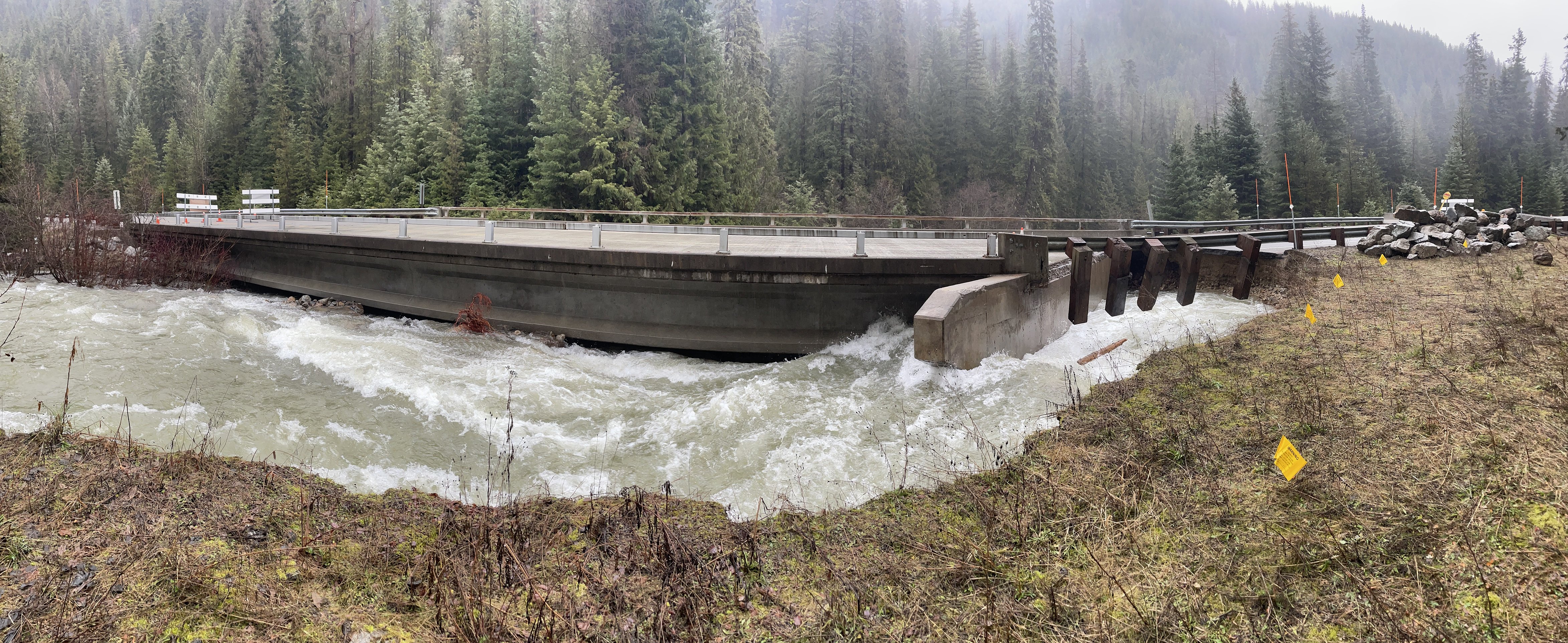 Floodwaters hit the Prospect Creek Bridge in Sanders County on Dec. 12, 2025. (Tracy Scott/Valley Press)
 Highway 471 near Prospect Creek was closed Dec. 12, 2025 due to flooding. (Tracy Scott/Valley Press)
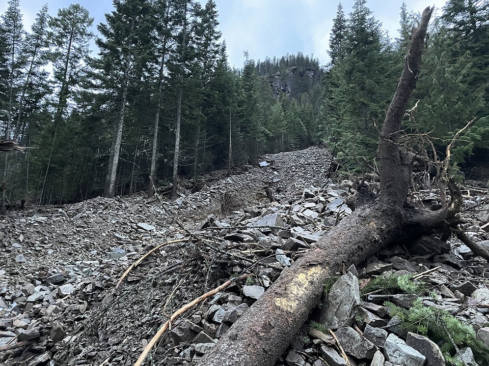 A rock and mudslide damaged a garage on Eagle View Lane in Sanders County on Dec. 11, 2025. (Tracy Scott/Valley Press)
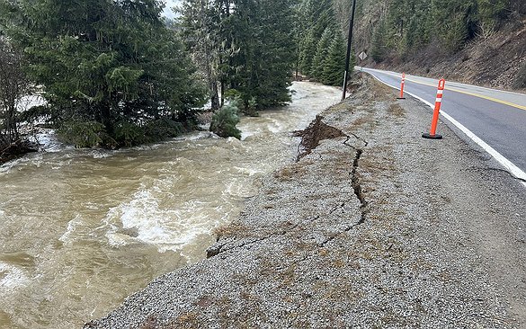 This section of Prichard Creek Road has much of its base layer washed out due to fast-moving floodwater crashing against it. (Josh McDonald/Shoshone Press)
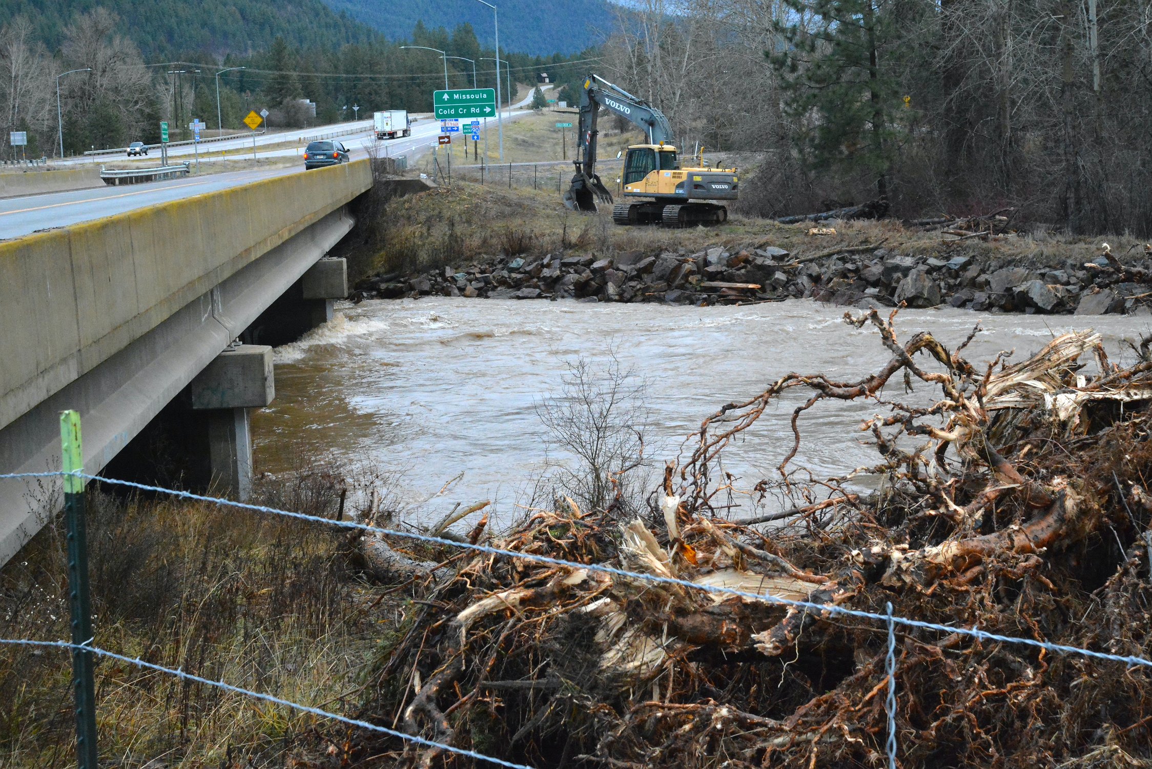 Workers removed a large pileup of trees and rootwods on December 11, which were washed downstream along the St. Regis River after several inches of rain. (Mineral Independent/Amy Quinlivan)
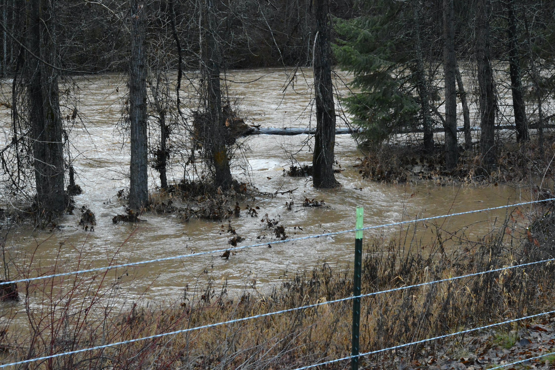 The river was inching very close to the Exit 33 off-ramp at St. Regis last week. The St. Regis River recorded higher flow rates three times higher flow rates than average spring runoff levels following a week's worth of December rainfall. (Mineral Independent/Amy Quinlivan)
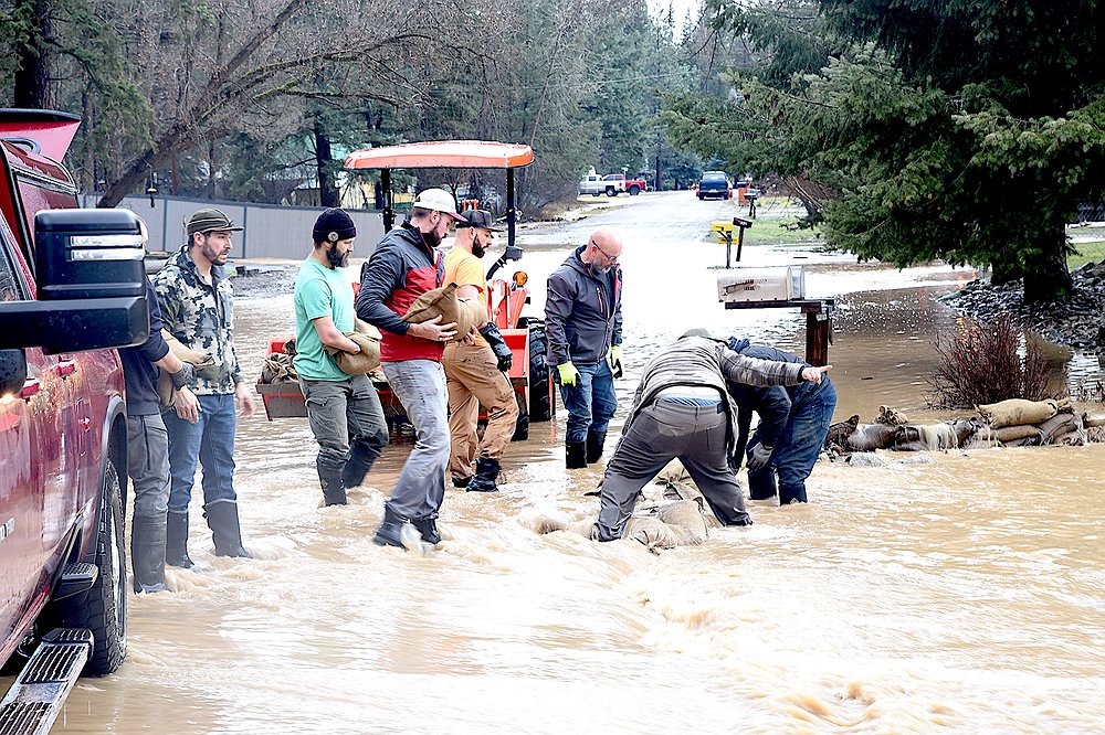 Volunteers place sandbags where Cherry Creek flooded south of Libby Thursday, Dec. 11, 2025. (Scott Shindledecker/The Western News)
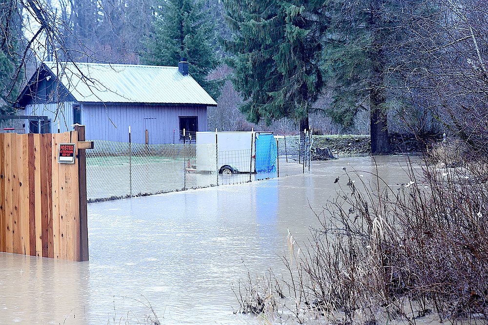 A property on Chase Cutoff was experiencing flooding from Lake Creek Thursday, Dec. 11, 2025, after days of rain and warm temperatures in south Lincoln County. (Scott Shindledecker/The Western News)
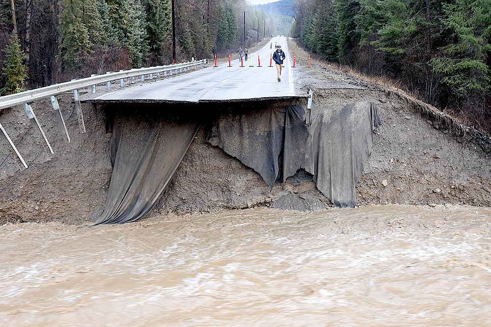 The bridge over Farm to Market Road south of Libby washed out early Thursday morning, Dec. 11, 2025, after days of rain and warm temperatures caused extensive flooding in south Lincoln County. (Scott Shindledecker/The Western News)
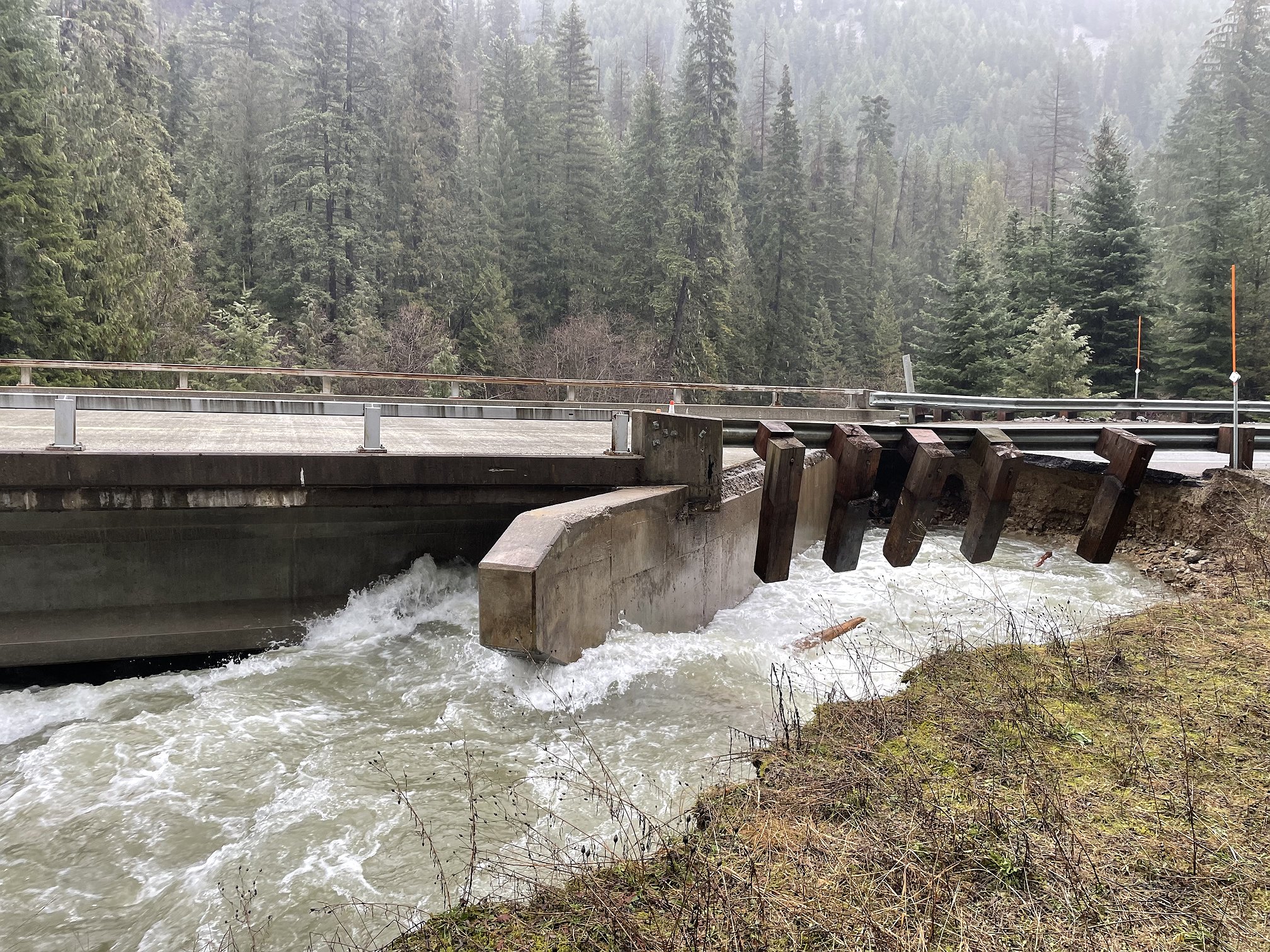 Floodwaters hit the Prospect Creek Bridge in Sanders County on Dec. 12, 2025. (Tracy Scott/Valley Press)
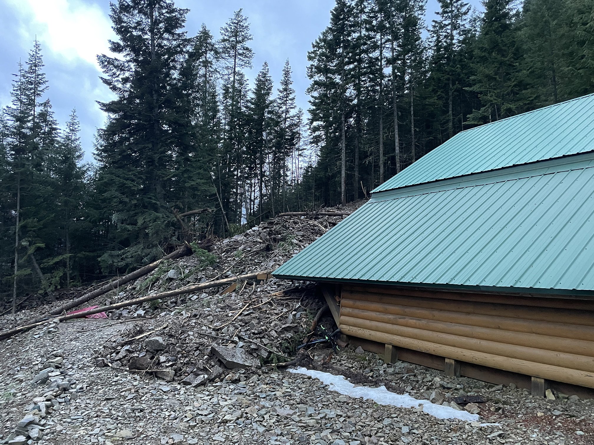 A rock and mudslide damaged a garage on Eagle View Lane in Sanders County on Dec. 11, 2025. (Tracy Scott/Valley Press)