
Athol brush fire prompts evacuations
CAROLINE LOBSINGER | Hagadone News Network | UPDATED 1 year, 1 month AGO
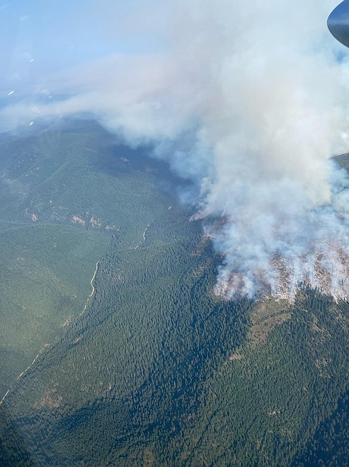
An aerial view of the Ulm Creek Fire.
Photo courtesy USDA FOREST SERVICE
I grew up in the Tri-Cities, Wash., and have always loved to write. I attended the University of Washington, where I earned a double major in journalism and political science, with an area of emphasis in history. I am the fifth out of six kids — don't believe any of the stories that my siblings tell. To be able to tell others stories and take photos for a living is a dream come true — and I considered myself blessed to be a community journalist. When I am not working, I enjoy spending time with family and friends, hiking and spending time outdoors, genealogy, reading, and watching the UW Huskies and the Seattle Seahawks. I am a servant to my cat, Frankie, who yes, will eat anything and everything in sight … even wedding cookies. | September 9, 2025 1:00 AM
SANDPOINT — Residents along a handful of roads near Athol were advised to leave their homes Monday afternoon due to a quickly moving brush fire.
The fire quickly grew after it was first reported at about 1:25 p.m., according to Idaho Department of Lands officials. Now estimated at between 10-15 acres, IDL officials said its crews are on scene and have been order, including nine engines, a dozen, four single-engine "scooper" planes, an air attack unit, and four hand crews.
The cause of the fire is under investigation.
Shortly after the fire was reported, the Bonner County Sheriff's Office placed residents on Sta off Mi Road, Candle Hill Road, Sagebrush Way, Parkwood Drive, Zeeland Road, Rain Drive and Angelwood Lane on "Go" status according to the state's "Ready-Set-Go" evacuation protocols.
In addition, residents on Rocksprings Road, Doe Run, Hatchet Lane, Genesis Lane, Trails End, Misty Meadows, Rodeo Road and Resort Road were placed on "Ready" status.
Under the Ready-Set-Go evacuation protocols, “Ready” means residents should have an evacuation plan, “Set” means they should begin implementing that plan and "Go" means residents should leave immediately and head to safety.
Real Life Ministries Church in Athol, 30447 Rough Stock Road, has been set as a reception area for evacuated residents. The church is located at the corner of Rough Stock and Highway 54.
Large animals, such as horses and cattle, and other farm animals such as sheep, pigs and goats were being directed to the Bonner County Fairgrounds on a space-permitting basis. No birds, cats, dogs or specialty pets will be allowed at the facility.
Owners must fill out the appropriate paperwork to identify their animals and must return to care for them as needed.
"The Bonner County Fairgrounds is proud to serve our community," Mark Knapp, Bonner County Fair director, said in a Nixle post outlining the evacuation procedures for the fairgrounds. "We thank you for your cooperation and understanding as we work together to keep our community and its animals safe."
Ulm Creek Fire
On the Ulm Creek Fire, located 16 miles north of Prichard on the Coeur d'Alene Ranger District, firefighters achieved 10% containment of the 2,529-acre fire. Started by a lightning strike Aug. 30, there are 149 personnel assigned to the fire, including four engines, several hand crews and water tenders and a variety of heavy equipment.
There are currently no evacuations associated with the Ulm Creek Fire, U.S. Forest Service officials said. A closure order for portions of the Idaho Panhandle National Forests and the Kootenai National Forest remains in place.
The fire's growth remained slow with most of the activity seen on the northern side of the fire in Montana. Firefighters continue to reinforce containment lines on the fire's western and northwestern flanks with work concentrated along the FSR 412 and 922 in Idaho as crews establish a 30-foot fuel break. In addition, heavy equipment and firefighters continue to create a defensible space around Gem Peak Lookout and the Gem Saddle Warming Hut in Montana.
Green Rattle Complex
On the Green Rattle Complex, which encompasses the Green Mountain, Rattle Mountain, Spruce and Spruce Ridge fires, 84 personnel are battling the 201-acre complex fire located on the Sandpoint Ranger District. A complex fire refers to when two or more wildfires have either grown together or are being managed under a single incident command.
Of the fires, the Green Mountain Fire has burned an estimated 8 acres, the Rattle Mountain Fire has burned 80 acres, the Spruce Fire 104 acres and the Spruce Ridge Fire has burned 9 acres. The fires have not grown in size for several days.
The Green Mountain Fire, located 8 miles west of Clark Fork, was detected in the wake of an Aug. 29 lightning storm, and is burning in steep, cliffy terrain above Lake Pend Oreille, commonly known as the Green Monarchs. Heavy equipment operators are continuing to thin fuels along Forest Service Road 278 and a hand crew is prepping Trail 69, as part of indirect lines. Firefighters will also continue structure protection assessments in the Kilroy Bay, Pine Cove, and Granite areas, USFS officials said. Road and trail closure orders remain in effect.
First detected Sept. 2, the Rattle Mountain Fire is showing moderate fire activity and is burning in steep, brushy terrain, with heavy fuels. Located 13 miles north-northeast of Clark Fork, some creeping, smoldering and backing has been observed. Thus far, firefighters and an engine — supported by helicopters, as needed — have been able to keep the fire north of FSR473. A road closure for a portion of the FSR473 remains in effect.
The Spruce Fire continued to be active Friday, primarily spreading by backing and flanking in large, dense timber both to the north and east, USFS officials said. First detected Sept. 1, the fire is burning in steep, rugged terrain, approximately 12 miles southwest of Troy, Mont.
The fourth fire in the complex, the Spruce Ridge Fire, was also detected Sept. 1, burning on a remote ridgeline associated with Spruce Mountain, approximately 13 miles southwest of Troy. Fire activity is "fairly quiet" with no significant growth seen, USFS officials said.
Lightning Creek Fire
The Lightning Creek Fire remains at 25% containment. Located nine miles north of Clark Fork, 109 personnel are assigned to the 2,515-acre fire.
Roads and trails surrounding the region's fire are closed for firefighter safety as well as that of the public. In addition, a temporary flight restriction is in effect around the fire areas.
Smoke and haze will continue to moderate fire behavior across all incidents, fire officials said. However, a chance of afternoon thunderstorms and associated winds could increase fire behavior.
"These storms may produce erratic winds, which could impact fire behavior and suppression efforts," officials said in an update. "Despite the incoming moisture, fuel conditions remain extremely dry, maintaining elevated fire risk."
Information: inciweb.wildfire.gov
ARTICLES BY CAROLINE LOBSINGER

Wellness fair puts focus on health
The Wellness & Connection Fair is bringing together local health and wellness professionals together in Sandpoint for a day of presentations, activities and community resources.

BCSD pays share of ISBT shortfall
District opts to make lump sum payment
Boundary County School District paid $217,000 to cover its share of the Idaho School Benefit Trust's $13 million shortfall.

Deadline extended for 'Valor' stories
The Valor publication is gathering photos, military service details and personal stories from Boundary County veterans and military families. Featured profiles highlight local service members' contributions, achievements and sacrifices across generations.