
Upper Smith Fire continues to grow
CAROLINE LOBSINGER | Hagadone News Network | UPDATED 3 months, 1 week AGO
I grew up in the Tri-Cities, Wash., and have always loved to write. I attended the University of Washington, where I earned a double major in journalism and political science, with an area of emphasis in history. I am the fifth out of six kids — don't believe any of the stories that my siblings tell. To be able to tell others stories and take photos for a living is a dream come true — and I considered myself blessed to be a community journalist. When I am not working, I enjoy spending time with family and friends, hiking and spending time outdoors, genealogy, reading, and watching the UW Huskies and the Seattle Seahawks. I am a servant to my cat, Frankie, who yes, will eat anything and everything in sight … even wedding cookies. | July 16, 2026 1:00 AM
BONNERS FERRY — The Upper Smith Fire has grown to 567 acres, U.S. Forest Service officials said Wednesday morning.
Burning in steep, rugged terrain, the Upper Smith Fire is steadily growing in northern Boundary County, officials said on InciWeb, an interagency incident information management site.
Reported July 8, the fire was sparked by a lightning strike in the overnight hours between Tuesday, July 7, and early Wednesday, July 8. As of Wednesday morning, there is 0% containment.
The fire, which is burning on a north-facing slope, is in an area of large logs and dead and down timber under a dense canopy, U.S. Forest Service officials said. A total of 40 firefighters have been assigned to the wildfire, including Hotshot crew, two hand crews, multiple engines and heavy machinery, and aviation support.
The fire is located about 6 miles west of Porthill and about 20 miles northwest of Bonners Ferry.
A complex incident management team has been ordered and is expected to take command of the fire Friday morning, officials said. A CIMT brings additional organizational capabilities to support the next stages of suppression. In addition, more resources were expected to arrive Wednesday morning.
USFS officials said firefighters will begin constructing both indirect and direct lines on the southwest corner of the fire. The lines will go from USFS Road 635 down the avalanche chute along the west flank toward USFS Road 2443.
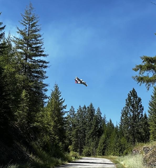
At the same time, an excavator will work to create a line from the end of USFS Road 635 east toward the ridge and heavy equipment will improve road access in the area. On the east side of the fire, crews will continue construction of handline on the north side of USFS Road 281 near the mouth of the drainage. Scouting for other containment opportunities also continues and helicopters and plane scoopers will be available to drop water on the fire as needed.
Forest Service officials praised the help from local fire districts, saying their work has been helpful in battling the blaze.
At Monday's community meeting, USFS officials said the fire is burning hot because of the "ridiculous amount" of fuel load in the area. As a result, it is too dangerous for fire crews to make direct attacks on the fire at present.
"We say it a lot, but as the saying goes, you know this is this is going to be a marathon, not a sprint," Bonners Ferry District Ranger Heather Fuller told those gathered. "This fire is in a tough spot. We're throwing what we can at it, and we're working on plans to try to put it out or keep it where it's at, and not have adverse impacts to those critical values at risk."
Objectives on the fire are "pretty simple," Ryan Wagner, USFS Type 3 Northern Idaho Team incident command trainee, said.
"We're going to aggressively suppress the Upper Smith Fire to limit the fire growth as much as possible," Wagner said. "We're going to confine the fire to minimize impacts to identified values at risk, and provide public and responder safety throughout all the operations.
The plan is to keep the fire west of Westside Road, south of Smith Creek Road and east of the avalanche chute. Firefighting efforts are going well in what is an extremely steep and rugged area.
"Everything is going as well as it could. I would say it's a really, really hard place to put people," Wagner said. "The fuels are really deep. The hillside's really steep, and to get people out there is really hard. That being said, we're doing what we can so far."
Much of the fire is burning in areas where a direct assault would make it difficult to extract an injured firefighter quickly, Jonathan Olson, U.S. Forest Service long-term analyst, said.
The fire is growing roughly 30 to 60 feet per hour and, due to the heavy fuel load, the flame lengths range between one and four feet.
"When we get into the four-foot range flame lengths, it's too intense to put people direct to the fire," Olson said.
The other hindrance to a direct assault is the intensity of the fire, caused in large part by the volume of fuel on the ground. Falling trees are also a significant concern because of the increased safety risk to firefighters.
"It's too intense to put people direct to the fire," Olson told residents gathered for the meeting, with some asking if the fire would be actively fought or "managed."
Other residents expressed concern over past treatment, contending homeowners had been disrespected and dehumanized.
"Every time one of these fires is allowed to run free and run amuck, our insurance rates either go through the roof or we're in danger of being dropped from our insurance," one woman said. "All of us out here on the west side, all of us in the area that live anywhere near woods, this is what we're experiencing right now as a direct result of the Kootenai Complex fire."
The Kootenai River Complex wildfire began in mid-July 2022 when the Diamond Watch Fire was sparked by a lightning strike. It quickly merged with other nearby fires — the Eneas Peak, Katka, Russell Mountain, Scotch Creek and Trout fires — forming the Kootenai River Complex. By the time it was over, the fire had burned more than 15,640 acres.
Management team officials assured residents that the Upper Smith Fire is considered a "full suppression fire" and every effort is being made to fight the fire while keeping homeowners, critical assets and firefighters safe.
"Given the terrain and the features we have and what the cards have dealt us at this point," officials said. "That's what we're using to help so we can access, and gain access … for folks to engage (the fire) directly."
Fire crews have continued structure prep work around key assets, testing sprinkler systems and triaging where additional sprinkler systems could be added, Waylon Meek told community members gathered for the meeting.
In addition, crews are also scouting where potential direct lines could go if the opportunities present themselves. Sites have also been earmarked for where heavy equipment can be deployed to open some of the roads and boost access to the fire area.
In addition to fire crews and heavy equipment, management team officials said aviation resources, including helicopters and scooper planes, are being utilized.
"All the aircraft we have at our disposal, we are using," officials said.
USFS Type 3 Northern Idaho Team members said the first priority is being placed on human life, followed by critical values such as homes and structures such as the Smith Creek hydropower facility. Added to that list are industrial timberlands located near the wildfire and a large power line.
"Some of the other things that we're definitely aware of and trying to protect, we recognize that out in the valley there's big fields with ready to be harvested and not harvest yet," Fuller said. "We've got some really nice beautiful wheat out there and the hops fields are a little bit south, so we recognize that it's also a threat to those."
With the U.S.-Canada border nearby, Fuller said crews are working to keep the wildfire on the U.S. side.
"We don't want to set it to our Canadian neighbors," the ranger said.
An ongoing cloud cover, which is expected to continue through Wednesday, has helped moderate fire behavior. Light winds have helped disperse smoke without fanning fire behavior, officials said.
Both Smith Creek Road and Long Canyon Trail have been closed to public travel. Closures in the Westside and Kerr Lake road areas, as well as a closure of Riverside Street, are connected to county projects.
USFS officials reminded area residents that temporary flight restrictions are in effect over the Upper Smith Fire to ensure the safety of suppression aircraft.
Info.: shorturl.at/viAB9
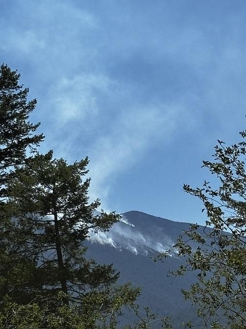
 Upper Smith Fire puts up a weak smoke column on Monday, July 13.
ARTICLES BY CAROLINE LOBSINGER

Wellness fair puts focus on health
The Wellness & Connection Fair is bringing together local health and wellness professionals together in Sandpoint for a day of presentations, activities and community resources.

BCSD pays share of ISBT shortfall
District opts to make lump sum payment
Boundary County School District paid $217,000 to cover its share of the Idaho School Benefit Trust's $13 million shortfall.

Deadline extended for 'Valor' stories
The Valor publication is gathering photos, military service details and personal stories from Boundary County veterans and military families. Featured profiles highlight local service members' contributions, achievements and sacrifices across generations.