
Storms pose threat to area wildfires
CAROLINE LOBSINGER | Hagadone News Network | UPDATED 3 months AGO
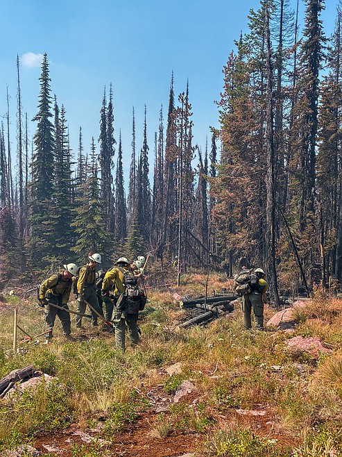
A hand crew uses pulaskis as they work on a fire line near Smith Ridge.
Photo courtesy USDA FOREST SERVICE
I grew up in the Tri-Cities, Wash., and have always loved to write. I attended the University of Washington, where I earned a double major in journalism and political science, with an area of emphasis in history. I am the fifth out of six kids — don't believe any of the stories that my siblings tell. To be able to tell others stories and take photos for a living is a dream come true — and I considered myself blessed to be a community journalist. When I am not working, I enjoy spending time with family and friends, hiking and spending time outdoors, genealogy, reading, and watching the UW Huskies and the Seattle Seahawks. I am a servant to my cat, Frankie, who yes, will eat anything and everything in sight … even wedding cookies. | July 21, 2026 1:00 AM
BONNERS FERRY — Pending thunderstorms pose the most serious risk to efforts to contain the Upper Smith Fire, Northern Rockies Complex Incident Management Team officials told the 60 or so residents who turned out for Monday's fire information meeting.
However, officials said the Turner Fire is fully lined and containment has reached 67% on the fire, located 5 miles south of Copeland.
Efforts to bring the Upper Smith Fire into some degree of containment could take a week or so, depending on a variety of factors, Northern Rockies Complex Incident Management Team officials told area residents at the community meeting.
Noah Myers, Northern Rockies incident meteorologist, said the area is seeing a warming trend with the chance for showers and thunderstorms later in the week.
Northern Rockies long-term fire behavior analyst LaWen Hollingsworth said that, looking back historically, only 4% of the records taken in the past 20 years show the area burning hotter than it is currently.
While the Turner Fire is "in great shape" from a fire behavior perspective, Hollingsworth said the Upper Smith Fire is hung up in an avalanche chute and could see growth into the next drainage and to the north.
With the expected thunderstorms Thursday and Friday, Hollingsworth said outflow winds from the storms could cause problems.
"Those really gusty winds that come with a thunderstorm can really push a fire around in unknown ways," she added. "So we will be very vigilant in watching for that."
More than 60 residents from northern Bonner County turned out for the community meeting.
U.S. Forest Service officials said the Turner Fire, located 5 miles south of Copeland, is 67% contained. There are 243 personnel assigned to the fire, which has burned 681 acres. Crews assigned include eight hand crews, 15 engines, two dozers and two water tenders.
The entirety of the Turner Fire is lined and forward progression has been stopped, Northern Rockies operations section chief Scott Schrenk told residents.
A strong initial attack and a full suppression effort by local, state and federal firefighters have the Turner Fire "looking very good," he said.
"(Local crews) sent a bunch of resources there, and I mean they hammered on it that first night, and then we came in … and then jumped in and took the fire," Schrenk said. "So it was a very good, clean, aggressive handoff, and basically caught the fire. Now we just need to clean it up."
On the Upper Smith Fire, crews are working toward direct containment and attempting to box in the fire on the fire's western flank. However, the rugged and steep terrain — as well as a heavy fuel load — poses challenges in fighting the fire and determines where crews can lay fire lines and make indirect and direct attacks on the fire.
"We're all in on this," Schrenk said.
Sunday, firefighting crews worked to reinforce and secure the constructed fire lines, mopping up areas where residual heat remains, Northern Rockies Complex Incident Management Team 1 officials said. However, despite the gusty winds, the fire produced less interior smoke than the day before.
"This is an indication that the fire has consumed the majority of unburned fuels within the perimeter," officials said.
Hand and engine crews worked to strengthen and secure fire lines, checking for potential hot spots and working to mop up those areas, officials said. That work is expected to last several days.
"Turner is in great shape from a fire behavior perspective," incident team officials said.
On the Smith Fire, located 20 miles northwest of Bonners Ferry, the lightning-caused fire has burned 815 acres since it was reported early July 8.
There are 347 personnel assigned to the fire, including three helicopters, eight hand crews and assorted heavy equipment, including engines, water tenders and excavators.
The fire is continuing to back down the north slope toward Smith Creek and remains active along the ridgetop south of the Long Canyon Fire scar.
"The primary focus is to prevent any eastward spread to protect homes, infrastructure, and other values at-risk along Westside Road, Smith Creek Canyon, and the Kootenai River corridor," officials said.
Firefighters are working to strengthen the hand line on the west flank as they work to improve existing control features along the avalanche chute extending to Smith Creek, officials said. Crews are also installing a hose lay in the southwest corner to enhance water support along the fire’s edge. Aerial support is available to reinforce retardant lines along the ridgetop.
In the coming days, heavy equipment will support indirect line construction along Westside Road from Long Canyon Creek to Smith Creek, thinning vegetation and removing fuels to create a shaded fuel break. Direct and indirect full-suppression tactics remain in place, with continued emphasis on protecting critical values and minimizing firefighter exposure to risk, officials said.
Both Smith Creek Road and Long Canyon Trail have been closed to public travel. Closures in the Westside and Kerr Lake road areas, as well as a closure of Riverside Street, are connected to county projects.
Temporary flight restrictions are in effect over both fires to ensure the safety of suppression aircraft. Both personal aircraft and drones are included in the TFR.
The Copeland and Porthill boat launches have reopened, but Boundary County Sheriff Travis Stolley cautioned residents to be aware that aerial resources could be present if water is needed to cool the fire. That means that residents "need to clear the area" if they see any near the Kootenai River and to be cognizant that possibility exists.
Info.: inciweb.wildfire.gov
ARTICLES BY CAROLINE LOBSINGER

Wellness fair puts focus on health
The Wellness & Connection Fair is bringing together local health and wellness professionals together in Sandpoint for a day of presentations, activities and community resources.

BCSD pays share of ISBT shortfall
District opts to make lump sum payment
Boundary County School District paid $217,000 to cover its share of the Idaho School Benefit Trust's $13 million shortfall.

Deadline extended for 'Valor' stories
The Valor publication is gathering photos, military service details and personal stories from Boundary County veterans and military families. Featured profiles highlight local service members' contributions, achievements and sacrifices across generations.