
Upper Smith Fire triggers evacuations
CAROLINE LOBSINGER | Hagadone News Network | UPDATED 2 months, 4 weeks AGO
I grew up in the Tri-Cities, Wash., and have always loved to write. I attended the University of Washington, where I earned a double major in journalism and political science, with an area of emphasis in history. I am the fifth out of six kids — don't believe any of the stories that my siblings tell. To be able to tell others stories and take photos for a living is a dream come true — and I considered myself blessed to be a community journalist. When I am not working, I enjoy spending time with family and friends, hiking and spending time outdoors, genealogy, reading, and watching the UW Huskies and the Seattle Seahawks. I am a servant to my cat, Frankie, who yes, will eat anything and everything in sight … even wedding cookies. | July 28, 2026 8:43 PM
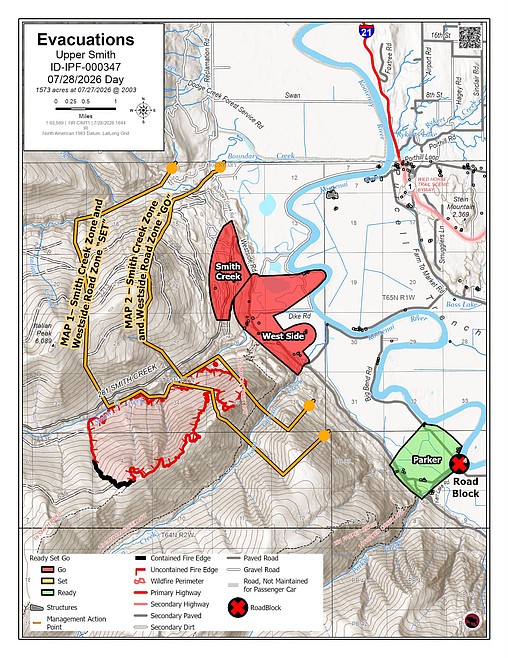
BONNERS FERRY — The Upper Smith Fire has reached the point where evacuation is necessary, Boundary County Sheriff Travis Stolley said Tuesday.
"Leave now," Stolley said bluntly in a social media post on the department's Facebook page. "If you are in either of these zones, evacuate immediately. Law enforcement and fire personnel will be in the area to assist and notify."
Two zones connected to the fire — the Westside and Smith Creek zones — were advised at 4:40 p.m. Tuesday that evacuation protocols had been moved to "Go."
Under "Ready" status, residents are advised to have a plan to evacuate if necessary; under "Set" status, residents are advised to begin putting their plan into place. Under "Go" status, residents are advised to leave immediately due to an imminent threat.
The notice follows a Monday community meeting at Mount Hall Elementary in which Stolley and Northern Rockies Team 1 officials warned that evacuations were a matter of when and not if.
Telling residents he was being "brutally honest," Stolley said that "Go" status could come within a day, two days or three. It ended up being just under one day.
While he won't come to their homes and force them to leave, Stolley said he hopes residents will leave to allow crews to focus on fighting the fire.
"I'm just asking for your consideration when we hit that Go status," the sheriff said at Monday's meeting. "I'm taking all of these things into consideration and you need to obviously make the decision what you think is best for you. But if that fire comes and we're having to deal with that extra piece, you know we really ask that you take that recommendation seriously."
Deputies are manning a roadblock set up at the intersection of Big Bend and Kerr Lake roads to protect property and homes in the evacuation zone. The Boundary County Fairgrounds has been designated as a rally point for residents, Stolley said.
Crews spent part of the day Tuesday securing the fireline as the fire continued to back down to Smith Creek. On Wednesday, crews are scheduled to patrol the fire's perimeter and work to secure completed firing operations along Smith Creek while continuing preparations for the next phase of work on the east side of the fire.
The fire's southern and eastern flanks continue to hold with containment of the fire estimated at 15%, Trevor Unsworth, Northern Rockies Team 1 operations section chief, said in an afternoon briefing posted to the Idaho Panhandle National Forests social media accounts.
But, in reality, we're being conservative on what we're calling contained," Unsworth said, noting that an avalanche chute on the west flank and a fire scar from the 2022 Long Canyon Fire are keeping the fire from moving.
"The fire's hung up in the avalanche chute," he said in the update. "The fire's secure but there's no actual line on the ground, that's why we're not showing it as contained. Same thing along this Long Canyon Fire scar. This stuff hasn't moved in 10 days. 90% of its completely out; it's not going anywhere but there's no physical line on the ground."
The day served as a "holding pattern" as crews prepared to bring the fire around a knob on the fire's eastern edge on Wednesday, Unsworth said. Crews are expected to spend several shifts working to bring the fire to a hand line on the Long Canyon hiking trail and a nearby rock face.
"We're going to hang it up on that with aircraft and potentially retardant," he said.
Crews are nearly completion on an indirect line east of the fire, running from the Canadian border on the north to Parker Creek on the south.
"Things are going super well, and we expect to have a lot of this stuff locked in and tied up before the weekend if things go as planned," Unsworth said.
The fire has burned roughly 1,573 acres since it was reported following a July 8 lightning strike. There are 410 personnel assigned to the fire, including five helicopters, five hand crews, 13 engines, 12 water tenders and assorted heavy equipment.
Northern Rockies Team 1 officials said fire crews worked Tuesday to secure the newly burned areas and continued preparing control lines between Smith Creek and Westside Road.
"Helicopter water drops helped limit the fire’s eastward movement while crews strengthened line and protected nearby structures and other values at risk," officials said in an update on InciWeb, an interagency incident information management site.
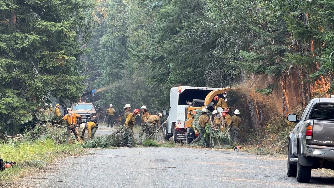
As conditions permit, crews will begin additional firing operations to gradually move fire from the Smith Creek drainage toward prepared control features west of Westside Road. Heavy equipment, chippers, and hand crews will continue improving those lines, officials said.
Aircraft and helicopters will continue to assist with water drops and fire retardant as needed, and smoke will remain visible.
Temporary flight restrictions are in effect over both fires to ensure the safety of suppression aircraft. Both personal aircraft and drones are included in the TFRs. Northern Rockies Team 1 officials said there have been several incidents of private drones flying in the TFR zone, which prevents the team's helicopters and planes from taking off.
Anyone caught flying a drone or a private aircraft can face up to $100,000 in fines and up to a year in federal prison.
Both Smith Creek Road and Long Canyon Trail have been closed to public travel. Closures in the Westside and Kerr Lake Road areas, as well as a closure of Riverside Street, are connected to county projects. The Parker Ridge Trail is in the process of being closed due to its access to the bridge construction and its proximity to road prep work related to the Upper Smith Fire.
While both the Copeland and Porthill boat launches are open, residents are advised to watch for aerial resources that may need to access the Kootenai River for water drops if water is needed to cool the fire.
Information: InciWeb.wildfire.gov
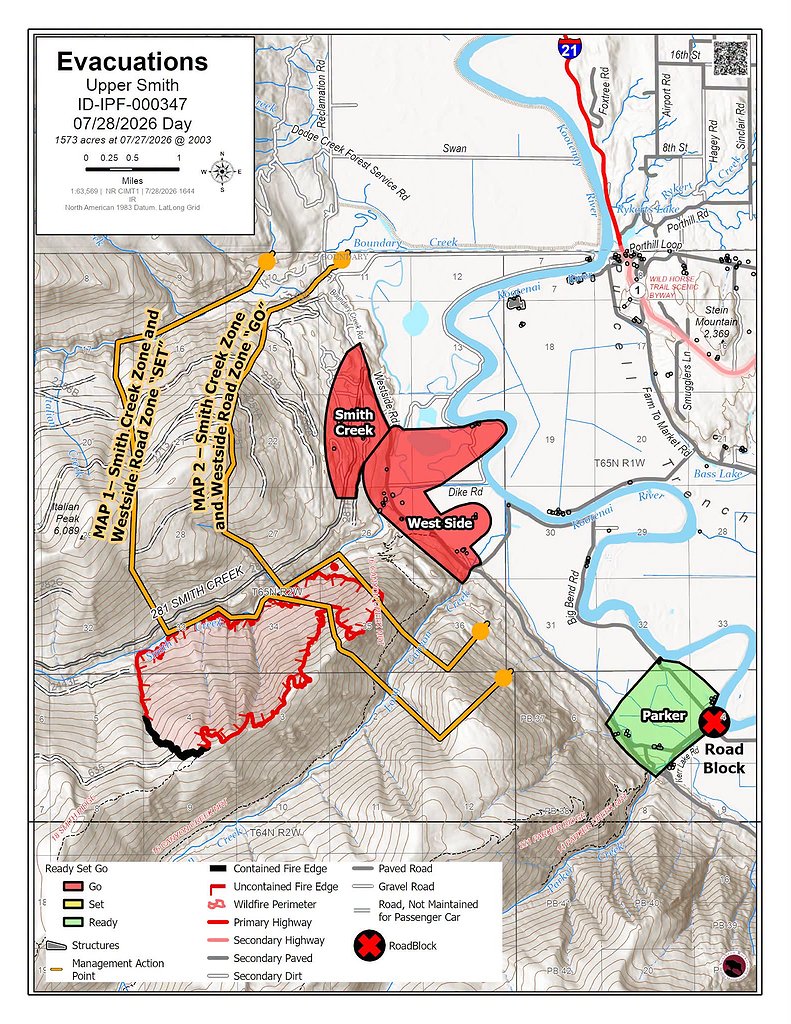 A map showing the evacuation zones on the Upper Smith Fire.
ARTICLES BY CAROLINE LOBSINGER

Wellness fair puts focus on health
The Wellness & Connection Fair is bringing together local health and wellness professionals together in Sandpoint for a day of presentations, activities and community resources.

BCSD pays share of ISBT shortfall
District opts to make lump sum payment
Boundary County School District paid $217,000 to cover its share of the Idaho School Benefit Trust's $13 million shortfall.

Deadline extended for 'Valor' stories
The Valor publication is gathering photos, military service details and personal stories from Boundary County veterans and military families. Featured profiles highlight local service members' contributions, achievements and sacrifices across generations.