Wind gusts near 100 mph, thousands lose power in winter blast
MATT BALDWIN and SCOTT SHINDLEDECKER | Daily Inter-Lake | UPDATED 3 hours, 33 minutes AGO


The Flathead Valley was spared from the worst of a winter storm that knocked out power in southern Lincoln County and buried mountains on the Montana-Idaho border in a foot of snow.
About 4,300 Flathead Electric Cooperative customers were without power at 6 a.m. Thursday as the storm barreled into the region. That number was pared down to 3,000 by late afternoon as co-op crews were aided by teams from Rocky Mountain Contractors.
The outages stretched from Troy and Libby to Marion along U.S. 2 west of Kalispell. Areas along the east shore of Flathead Lake and near West Glacier and Essex also experienced outages.
Public schools were closed regionwide Thursday in anticipation of the storm.
Impressive wind speeds were reported across western Montana, with Tunnel Ridge in the Flathead Range recording a 96-mph gust and the Spotted Bear Lookout clocking an 89-mph gust.
In the valley, a location northwest of Bigfork registered a 63-mph gust, Kalispell saw wind speeds hit 58 mph and Whitefish had a 44-mph gust.
The winds peaked around 8 a.m. for most locations.
In Libby and Troy, the storm toppled trees onto powerlines and homes. While the damage was not as extensive as the December windstorm that wreaked havoc on southern Lincoln County, it was dangerous enough that officials issued travel restrictions through the morning hours. The Montana Department of Transportation reported a number of downed trees on U.S. 2 and Montana Highways 56 and 200 in the predawn hours Thursday.
Mountains along the Montana and Idaho border saw the most snow Thursday. Lolo and Lookout passes west of Missoula each tallied about 12 inches, and Hoodoo Basin picked up 16 inches.
The bulk of the precipitation remained on track to hit the region Friday into Saturday, the National Weather Service in Missoula warned, though the forecast was tricky due to an arctic front that may dip into Northwest Montana.
“The atmospheric river is still streaming into the region with the bulk of the precipitation expected across north central Idaho into west central Montana through Saturday,” the Weather Service wrote in its forecast Thursday. “Snow levels continue to be the most difficult portion of the forecast over the next 24 hours.”
Mountains along the Montana-Idaho border and in Glacier Park are favored for heavy snowfall.
Due to wind and snow, the Flathead Avalanche Center issued a warning that natural and human-triggered slides are likely.
"Steer clear of avalanche terrain; even nibbling at the edges of a slope is likely a dangerous endeavor," forecaster Guy Zoellner warned.
In the Flathead Valley, a few inches of snow are possible through Saturday.
Beyond the weekend, pleasant temperatures in the 50s and 60s are likely by Tuesday.
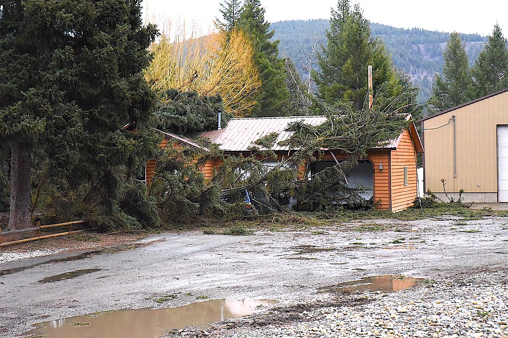 Snapped tree limbs hit a home on U.S. 2 Thursday, March 12, 2026, south of Libby. (Scott Shindledecker/The Western News)