
Water plan calls for dam on Glacier National Park's St. Mary Lake and lower St. Mary Lake
CHRIS PETERSON | Hagadone News Network | UPDATED 1 month AGO
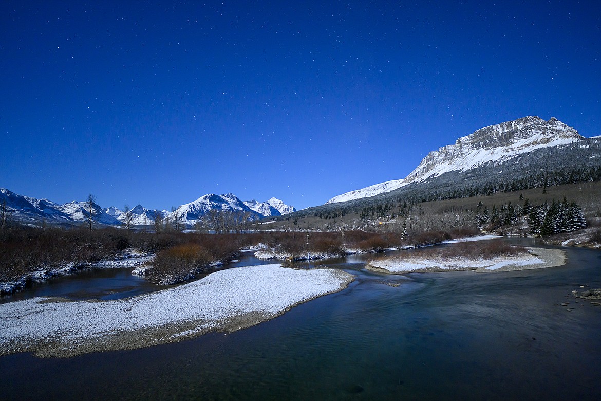
Stars over the St. Mary River.
Chris Peterson is the editor of the Hungry Horse News. He covers Columbia Falls, the Canyon, Glacier National Park and the Bob Marshall Wilderness. All told, about 4 million acres of the best parts of the planet. He can be reached at [email protected] or 406-892-2151. | September 16, 2026 7:45 AM
A study released earlier this summer suggests that inflatable dams on St. Mary and Lower St. Mary Lake could help in relieving future water use conflicts on the St. Mary and Milk River systems.
St. Mary Lake is in Glacier National Park and Lower St. Mary Lake is on the Blackfeet Indian Reservation. The iconic water bodies are currently unmolested by water control measures.
The International St. Mary and Milk Rivers Study, published in July, takes a long look at both river systems and the water usage of both the U.S. and Canada and the impending impacts of climate change.
One suggestion to keep the systems irrigating crops and providing water for communities in their drainages is to put inflatable dams on both lakes that would keep the water at a height of close to or near the regular high water mark for a longer period of time. The water, in essence, would be stored for use later in the summer for crop irrigation in both the U.S. and Canada.
Glacier National Park is already greatly impacted by the system, some might say scarred, by the Sherburne Dam, which holds back water from Swiftcurrent Creek flowing out of the Many Glacier Valley.
The seasonal rise and fall of the resulting Sherburne Lake results in a largely barren shoreline deep inside the boundaries of the park. Water from Sherburne Lake is diverted for irrigation and other uses farther downstream in both Canada and the U.S.
The St. Mary Canal, built in 1915, draws water off the St. Mary River below Lower St. Mary Lake and 29 miles later dumps it into the North Fork of the Milk River. The North Fork of the Milk River flows into Canada, where it’s used for crop irrigation and municipal water. It parallels the U.S.-Canada Border for about 90 miles and then flows back into the U.S. northeast of Havre, where it’s dammed to create the Fresno Reservoir.
The 140-plus page study recommends a host of other measures to keep the proverbial water flowing into the future, as climate changes promises warmer winters with less snow and hotter summers that will result in more usage.
The study doesn’t dive into the details of the proposed inflatable dams or how exactly they would work.
“Inflatable dam creates storage in both Upper and Lower St. Mary Lakes by retaining the spring freshet until later in the irrigation season. Lake levels will not exceed the typical high-water level naturally achieved. Seasonal maximum combined storage of both lakes is 16,800 acre-feet,” the study notes.
An acre-foot of water, which is the amount of water to cover 1 acre of land with 1 foot of water is about 325,000 gallons, so both dams would potentially hold back about 5.4 billion gallons of water.
The study also calls for maximizing the capacity of the St. Mary Canal to 850 cubic feet per second (it’s currently about 600 cubic feet per second) and building another reservoir in Canada on the Milk River.
With additional administrative changes to how the water is managed and allocated, the study suggests that both countries in the future would have most of their water entitlements maintained at 100 % or close to it for next 100 years.
What the study doesn’t look at are environmental impacts and overall costs of upgrading or adding the necessary infrastructure suggested in the study.
The St. Mary Canal, which works through a series of siphons and other water control structures had a major failure in June 2024. The cost to replace the St. Mary siphon near Babb and another one at Halls Coulee was about $100 million.
The St. Mary diversion dam has also been upgraded this year.
The study found that the larger improvements would largely benefit Canada economically by about $19 million to $33 million annually, while the U.S., in turn, would lose $4 million to $8 million annually if all the options were implemented.
There are also aesthetic considerations and impacts on Glacier National Park and the Blackfeet Tribe with inflatable dams.
Both water bodies are some of the most photographed in the world.
Glacier National Park officials did not respond to a request for comment on the proposed dams. No one from the project or the study returned phone calls seeking further information as well.
The study was commissioned by the International Joint Commission, a quasi governmental body of U.S., and Canada officials that oversees boundary water issues. The Boundary Waters Treaty of 1909 governs transboundary water issues for both countries and specifically the St. Mary and Milk River drainages.
“The study confirmed that while the apportionment (of the Boundary Waters Treaty) framework has generally functioned as intended, neither country has consistently been able to receive its full entitlement due to infrastructure constraints, operational limits, and timing mismatches between water availability and demand. Climate and hydrologic modelling underscored the urgency of adaptation, showing trends toward warmer conditions, reduced snowpack, altered runoff timing, more evapotranspiration, and greater drought risk—especially in the Milk River basin. By integrating forward-looking climate analyses, the study strengthened the basin’s preparedness and demonstrated the need for greater flexibility in water management,” the document notes.
The study now goes before the International Joint Commission for further review. A public comment period on the document ended Aug. 31.
ARTICLES BY CHRIS PETERSON

Stockman Bank opens Columbia Falls branch
Columbia Falls welcomed Stockman Bank in a grand opening last week, with more than 150 people attending.
If Pursuit gets permit to cross BPA power lines, it would be a first for the administration
If Pursuit is successful in securing the permits and building a tram up Columbia Mountain, it might be the only structure of its type that transports humans over Bonneville Power Administration transmission lines, a BPA spokesman noted last week.

Mountain goat study results in changes to rivers plan
Glacier National Park has been examining the movements of mountain goats and whether recreational use of the Middle Fork of the Flathead River is having an impact on them.