
Lightning sparks fire in steep, rugged terrain south of Thompson Falls
HAILEY SMALLEY | Hagadone News Network | UPDATED 2 months AGO
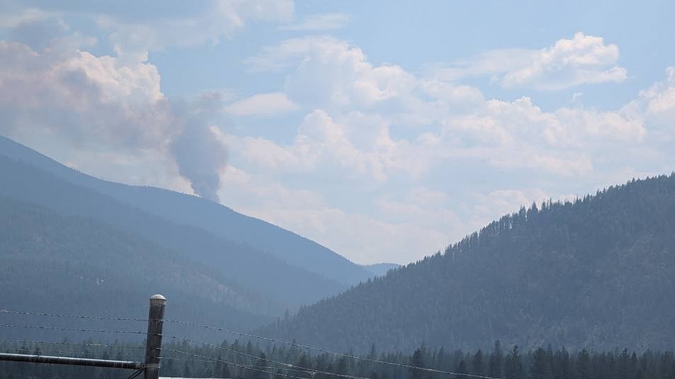
A column of smoke from the Cherry Peak Fire is visible from the area of the Thompson Falls airport on the afternoon of Aug. 18. (Courtesy InciWeb)
Dozens of firefighting personnel are battling a lightning-sparked blaze about 7 miles southeast of Thompson Falls in Lolo National Forest.
Smoke was first spotted rising above Cherry Peak just before 2 p.m. on Tuesday. An initial aerial response mapped the fire at about 10 acres, but dense vegetation and warm conditions spurred rapid growth along its northeastern perimeter. By 7 a.m. Wednesday, the fire had surged to 130 acres and remained zero percent contained.
Helicopters and air tankers dropped water and fire retardant along the fire line as part of the initial response, but the remote location, rugged terrain and heightened fire activity precluded more direct suppression efforts. More subdued fire activity Wednesday morning provided a window for smoke jumpers to parachute into the area. Ground crews, meanwhile, continued to bushwack a path to the blaze from Cherry Peak Road.
About 50 personnel were deployed on the Cherry Peak Fire as of Wednesday afternoon, and more crews were en route, according to Public Information Officer Brandalyn Vonk.
The fire is not currently threatening any buildings or infrastructure. Officials are hopeful that the nearby 2007 Cherry Creek Fire burn scar will serve as a natural buffer against blaze’s continued growth.
REGIONAL CREWS took over command of the Skillet Fire burning about 15 miles west of Olney in Flathead National Forest. A complex incident management team had assumed management of the blaze shortly after it was detected on July 29.
As of Aug. 19, the fire was estimated at 3,364 acres and 82% containment. More than 200 personnel remained on-site to help with mop-up operations, though officials said that equipment and crews would likely be re-assigned to higher priority incidents in the coming days.
Suppression efforts on the Skillet Fire currently total $20.9 million.
The Silvertip Fire burning deep in the Bob Marshall Wilderness has reached 6,681 acres. A stretch of limestone rocks and cliffs has hemmed the blaze's southern flank, preventing further growth in that direction. Officials described fire activity along the rest of the perimeter as minimal, with some smoldering and creeping in areas of dense vegetation.
Flathead National Forest updated public closures in the areas surrounding the Skillet and Silvertip fire on Aug. 13. A full description of closed roads and trails can be found online at fs.usda.gov/r01/flathead/alerts.
Reporter Hailey Smalley can be reached at 406-758-4433 or [email protected]. If you value local journalism, pledge your support at dailyinterlake.com/support.
ARTICLES BY HAILEY SMALLEY

Trump stumps for Flint in Kalispell as Election Day nears
President Donald Trump, wearing a dark suit, red tie and red USA cap, ambled into the Majestic Valley Arena to the raucous roar of a crowd.
Flathead National Forest greenlights Swan Valley timber project
A 2,307-acre timber project is now under way in the Swan Valley.
Flathead National Forest greenlights Swan Valley timber project
A 2,307-acre timber project is now under way in the Swan Valley.