
Montana-Idaho border reconfigured after survey retraces original state lines
MONTE TURNER | Hagadone News Network | UPDATED 1 day, 4 hours AGO
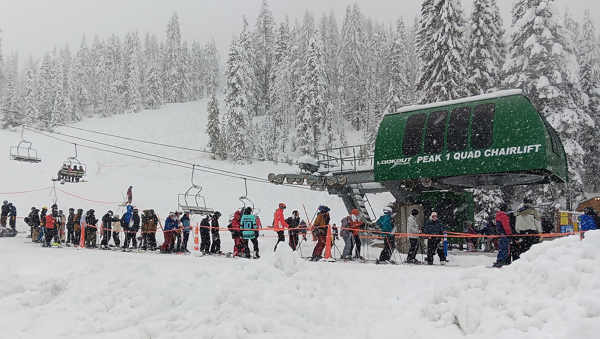
Do not let the lack of snow fool you thinking that Lookout Pass might be sketchy for skiing. Whenever the lower elevations are receiving rain, you can be sure it’s snow at the Montana/Idaho border.
For years, the Montana-Idaho boundary near Lookout Pass has been the subject of questions, maps that didn't quite agree and enough head-scratching to make a person wonder if the state line had simply wandered off for a while.
Now, after more than a century of history, the construction of I-90 and several decades of questions, the line has finally received another look. And this time, it came with surveyors.
The Bureau of Land Management has completed its official resurvey of the Montana-Idaho boundary near Lookout Pass, going back to the original survey monuments and retracing the line that was established more than 120 years ago.
The important part is this: Montana didn't move the line.
The survey was conducted to determine where the original line actually belongs. According to Scott Mendenhall, deputy director and public information officer for the Montana Department of Revenue, an assessment map from Idaho's Shoshone County somehow found its way into Montana's cadastral mapping system.
Over the years, some of the original boundary monuments disappeared, while roads, construction and other changes took place around Lookout Pass. Somewhere along the way, the paperwork apparently got a little more interesting.
Sen. Denley Loge, R-St. Regis, has been asking questions about the boundary for years. Loge, whose background includes road building and geography, first noticed discrepancies in the area decades ago. His concern was that the boundary appeared to have shifted south over time, potentially putting roughly 50 to 60 acres that should be in Mineral County on the Idaho side of the line.
The issue eventually got the attention of the Montana Department of Revenue, which funded the BLM survey. The BLM made it clear from the beginning that it didn't have the authority to move a state boundary. Its job was to go back to the original evidence and retrace the line.
The next step is considerably less glamorous than tromping around the Bitterroot Mountains with surveying equipment: paperwork.
Mendenhall said that the completed survey will need to be filed with the appropriate county clerk and recorder. If the survey affects only the portion of the boundary in Mineral County, it will be filed here. If the resurvey affects other counties, those counties will get a copy as well.
Once the survey is filed, the Montana Department of Revenue will update its parcel boundary records. In other words, after all the measuring, marking and retracing, somebody gets to sit down at a desk and make sure the computer agrees with the mountains.
Loge said he isn't expecting Mineral County to suddenly discover a pot of gold buried along the state line.
“I still don't expect a windfall,” he said.
But he added that the survey means officials can finally move forward with the boundary question answered.
“We did not change the boundary,” Loge said. “We just get to reclaim it without objection.”
There could be some financial benefit, but exactly how much remains to be determined. One possibility is additional PILT revenue.
Mineral County depends heavily on Payments in Lieu of Taxes because roughly 93% of the county is federally owned, most of it U.S. Forest Service land. PILT helps replace some of the tax revenue counties would otherwise receive if that federal land were privately owned and taxable.
If the amount of qualifying federal land attributed to Mineral County changes, the county's PILT calculation could change as well.
There could also be additional property-tax revenue associated with the Lookout Pass ski area. The Montana Department of Revenue plans to meet with resort personnel to go over the newly established boundary and determine which real and personal property is actually located on the Montana side. Some property that has been reported in Idaho could, depending on its location and classification, now properly belong on Montana's tax rolls.
People who have completed the Route of the Hiawatha may have pedaled right through another piece of the boundary puzzle without giving much thought to which state they were in. The Taft Tunnel is divided by the Montana-Idaho line. That raises an interesting question: If people are paying to ride bicycles through a tunnel that crosses the state line, does Montana get a piece of the action? Maybe.
The Montana Department of Revenue's Business and Income Taxation Division will take a look at the bicycle operation to determine whether income generated in Montana is being properly reported and whether any Montana taxes are owed. So, yes, even bicycles have managed to become part of the boundary discussion.
On a map, a state line is usually just that, a line. In the real world, however, lines can get lost. Monuments disappear. Roads get built. Survey markers get buried or dug up. Mountains get altered. Maps get copied. Somebody enters something into a computer that probably shouldn't have been entered that way. And before long, one state says the line is here while another map says it is somewhere else.
That's essentially what happened at Lookout Pass.
ARTICLES BY MONTE TURNER
Montana-Idaho border reconfigured after survey retraces original state lines
The Bureau of Land Management has completed its official resurvey of the Montana-Idaho boundary near Lookout Pass, going back to the original survey monuments and retracing the line that was established more than 120 years ago.
Montana-Idaho border reconfigured after survey retraces original state lines
The Bureau of Land Management has completed its official resurvey of the Montana-Idaho boundary near Lookout Pass, going back to the original survey monuments and retracing the line that was established more than 120 years ago.
Mineral County ride program making running errands a cinch
MCPC provides both regularly scheduled rides and unscheduled medical transportation, and the price depends on the type of trip.